
Hikes
Hikes
Scenic gondola ride for views at 10,700 ft. See website for tickets and booking. https://www.winterparkresort.com/things-to-do/activities/summer-scenic-gondola
331 (рекомендации местных жителей)
Winter Park Resort
85 Parsenn RdScenic gondola ride for views at 10,700 ft. See website for tickets and booking. https://www.winterparkresort.com/things-to-do/activities/summer-scenic-gondola
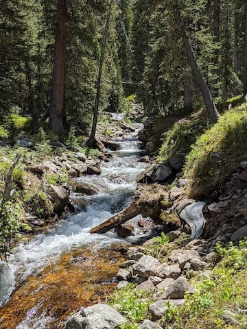
Second Creek / Broome Hut (Moderate due to elevation gain)
DISTANCE: 5 MILES ROUND TRIP
ELEVATION: TRAILHEAD 10,569’ / HUT 11,350’
Trailhead Location: From the Winter Park Information Center, follow US Highway 40 south and up the eastern side of Berthoud Pass. A turnout at mile marker 240 along with a large orange avalanche warning sign marks the trailhead.
Trail Description: The Second Creek Trail climbs 700’ in just one mile from to the Broome Hut, which overlooks an idyllic alpine basin. Begin along the main trail following the creek. Stay on the main trail until the cirque and eventually the hut become visible. A portion of the hut is available for day use. The Second Creek trail is popular year-round. To continue to the top of the Continental Divide, follow the trail around the right of the hut. The trail is defined for the first 1.5 miles as it crosses Second Creek and through willows, but then becomes faint as it enters the alpine tundra. Watch for rock piles that delineate the trail to the summit. From the top there are great views to the north of Parsenn Bowl, and to the east of Parry and James Peaks and the Continental Divide.
6 (рекомендации местных жителей)
Broome Hut
Second Creek / Broome Hut (Moderate due to elevation gain)
DISTANCE: 5 MILES ROUND TRIP
ELEVATION: TRAILHEAD 10,569’ / HUT 11,350’
Trailhead Location: From the Winter Park Information Center, follow US Highway 40 south and up the eastern side of Berthoud Pass. A turnout at mile marker 240 along with a large orange avalanche warning sign marks the trailhead.
Trail Description: The Second Creek Trail climbs 700’ in just one mile from to the Broome Hut, which overlooks an idyllic alpine basin. Begin along the main trail following the creek. Stay on the main trail until the cirque and eventually the hut become visible. A portion of the hut is available for day use. The Second Creek trail is popular year-round. To continue to the top of the Continental Divide, follow the trail around the right of the hut. The trail is defined for the first 1.5 miles as it crosses Second Creek and through willows, but then becomes faint as it enters the alpine tundra. Watch for rock piles that delineate the trail to the summit. From the top there are great views to the north of Parsenn Bowl, and to the east of Parry and James Peaks and the Continental Divide.
Discovery Trail / Jim Creek Trail (Easy to Moderate)
DISTANCE: 1.5 – 7 MILES ROUND TRIP
ELEVATION: TRAILHEAD 9,220’ / 1,225’ GAIN
Trailhead Location: From the Winter Park Information Center, follow US highway 40 south toward Winter Park Resort. Turn left at the 3rd stoplight and park at the Bonfils Stanton Outdoor Center directly across from Winter Park Resort entrance.
Trail Description: The first section begins with a boardwalk, and is the 1.5 mile Discovery Trail. At the campground, stay to the left of the picnic pavilion and an old road will be on the right, which parallels the trail. Shortly you will come to FS128. To follow the Discovery loop, veer to the left. For Jim Creek Trail, cross the road to the right of a water diversion and follow the trail. The Discovery Trail is handicap accessible, while the Jim Creek Trail is slightly more strenuous.
Jim Creek
Discovery Trail / Jim Creek Trail (Easy to Moderate)
DISTANCE: 1.5 – 7 MILES ROUND TRIP
ELEVATION: TRAILHEAD 9,220’ / 1,225’ GAIN
Trailhead Location: From the Winter Park Information Center, follow US highway 40 south toward Winter Park Resort. Turn left at the 3rd stoplight and park at the Bonfils Stanton Outdoor Center directly across from Winter Park Resort entrance.
Trail Description: The first section begins with a boardwalk, and is the 1.5 mile Discovery Trail. At the campground, stay to the left of the picnic pavilion and an old road will be on the right, which parallels the trail. Shortly you will come to FS128. To follow the Discovery loop, veer to the left. For Jim Creek Trail, cross the road to the right of a water diversion and follow the trail. The Discovery Trail is handicap accessible, while the Jim Creek Trail is slightly more strenuous.
Creekside / Flume Loop (Easy and one of our favorites with the dogs and best view of Byers Peak)
DISTANCE: 5 MILES ROUND TRIP
ELEVATION: 9,000’
Trailhead Location: From the Winter Park Information Center, follow US Highway 40 north to the Fraser Valley Center traffic light and turn left onto CR72. Turn right on CR721 (Fraser Parkway) and follow to the “T” intersection. Turn left onto CR73. Continue toward the St. Louis Creek campground and park.
Trail Description: Begin at St. Louis Creek campground. The trailhead for Creekside is on the north side of the parking area. If you have gone into the campground you have gone too far. Creekside will end on FS road 159. Turn left and look for Flume trail slightly uphill and on your left. Enter Flume, which is a heavily wooded forest and at times gives way to open meadows. The Flume trail gets its name from an old logging flume, which it parallels. The trail will go through some aspens before reaching the scenic overlook bench. Take time to enjoy the view of Byers Peak and St. Louis Creek. Shortly after the scenic overlook is a trail junction. Straight ahead is Chainsaw, turn left and the trail will take you across St. Louis Creek. Turn left after the bridge and follow an old road back to the campground.
Fraser Experimental Forest
Creekside / Flume Loop (Easy and one of our favorites with the dogs and best view of Byers Peak)
DISTANCE: 5 MILES ROUND TRIP
ELEVATION: 9,000’
Trailhead Location: From the Winter Park Information Center, follow US Highway 40 north to the Fraser Valley Center traffic light and turn left onto CR72. Turn right on CR721 (Fraser Parkway) and follow to the “T” intersection. Turn left onto CR73. Continue toward the St. Louis Creek campground and park.
Trail Description: Begin at St. Louis Creek campground. The trailhead for Creekside is on the north side of the parking area. If you have gone into the campground you have gone too far. Creekside will end on FS road 159. Turn left and look for Flume trail slightly uphill and on your left. Enter Flume, which is a heavily wooded forest and at times gives way to open meadows. The Flume trail gets its name from an old logging flume, which it parallels. The trail will go through some aspens before reaching the scenic overlook bench. Take time to enjoy the view of Byers Peak and St. Louis Creek. Shortly after the scenic overlook is a trail junction. Straight ahead is Chainsaw, turn left and the trail will take you across St. Louis Creek. Turn left after the bridge and follow an old road back to the campground.
Columbine Trail (Intermediate, and beautiful lake)
DISTANCE: 7 MILES ROUND TRIP
ELEVATION: 10,000'
Trailhead Location: From the Winter Park Information Center, follow US Highway 40 north toward CO Highway 83. Drive up a winding dirt road to the Junco Lake Trailhead via CR 84 / FS129. The trailhead is located in the Arapaho National Recreation Area and costs $5 per motor vehicle to access.
Trail Description: The trail starts out level and gains elevation as the trail turns to rocks. Once you pass remnants of an old cabin, the trail evens out into a natural dirt path. In addition to Columbine Lake, the trail features creeks, meadows, forest, and mountain views. As the lake nears, follow the trail past large boulders and several small meadows. Continue through an area of small ponds to where the trail reaches the lake.
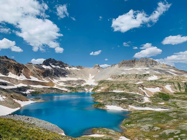
Columbine Lake
Columbine Trail (Intermediate, and beautiful lake)
DISTANCE: 7 MILES ROUND TRIP
ELEVATION: 10,000'
Trailhead Location: From the Winter Park Information Center, follow US Highway 40 north toward CO Highway 83. Drive up a winding dirt road to the Junco Lake Trailhead via CR 84 / FS129. The trailhead is located in the Arapaho National Recreation Area and costs $5 per motor vehicle to access.
Trail Description: The trail starts out level and gains elevation as the trail turns to rocks. Once you pass remnants of an old cabin, the trail evens out into a natural dirt path. In addition to Columbine Lake, the trail features creeks, meadows, forest, and mountain views. As the lake nears, follow the trail past large boulders and several small meadows. Continue through an area of small ponds to where the trail reaches the lake.
Monarch Lake Loop Trail (Easy)
Distance: 4.0 miles round trip
Elevation: 8400'
Trailhead location: Take Hwy 40 towards Granby, Take a right on Hwy 34 and continue on 34 until you see County Road 6. Turn right on County Road 6, be sure to make a quick stop at the pay station to obtain a $5 day pass for access to the Arapaho National Recreation Area. Continue on CR-6 for about 10 miles (be aware that the road becomes unpaved and gets pretty bumpy, but is not steep). The road will dead-end at a large parking area, beyond which the ranger station, restrooms, and trailhead are located. There is also a great spot here for paddlers to put in a kayak, canoe, or paddleboard to gain access to the lake’s few small islands. Although this trail is popular and the parking area is often crowded, many are there to explore the variety of spurs off the main trail which lead to backcountry campsites and other lakes, leaving the main trail relatively quiet.
Trailhead Description: From the trailhead, a shaded tunnel of trees leads down a short gravel path to the Wilderness Information Cabin. Here you can pick up trail maps and information about hikes up into the Indian Peaks Wilderness area. The trail description here is of hiking the Monarch Lake Loop in a clockwise fashion. Begin on the Cascade Creek trail #N1. This will follow the shoreline of the lake and soon enter the forested area along the Northern end of the lake. After approximately 1 mile, the landscape changes and enters a wetland marsh. Keep your eyes peeled for moose and other wildlife here.
30 (рекомендации местных жителей)
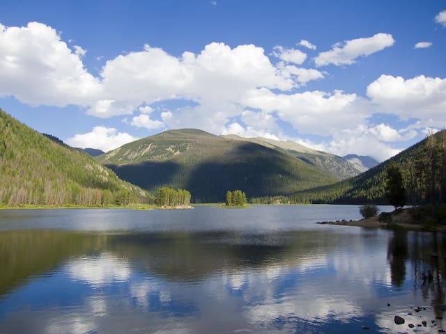
Monarch Lake
Monarch Lake Loop Trail (Easy)
Distance: 4.0 miles round trip
Elevation: 8400'
Trailhead location: Take Hwy 40 towards Granby, Take a right on Hwy 34 and continue on 34 until you see County Road 6. Turn right on County Road 6, be sure to make a quick stop at the pay station to obtain a $5 day pass for access to the Arapaho National Recreation Area. Continue on CR-6 for about 10 miles (be aware that the road becomes unpaved and gets pretty bumpy, but is not steep). The road will dead-end at a large parking area, beyond which the ranger station, restrooms, and trailhead are located. There is also a great spot here for paddlers to put in a kayak, canoe, or paddleboard to gain access to the lake’s few small islands. Although this trail is popular and the parking area is often crowded, many are there to explore the variety of spurs off the main trail which lead to backcountry campsites and other lakes, leaving the main trail relatively quiet.
Trailhead Description: From the trailhead, a shaded tunnel of trees leads down a short gravel path to the Wilderness Information Cabin. Here you can pick up trail maps and information about hikes up into the Indian Peaks Wilderness area. The trail description here is of hiking the Monarch Lake Loop in a clockwise fashion. Begin on the Cascade Creek trail #N1. This will follow the shoreline of the lake and soon enter the forested area along the Northern end of the lake. After approximately 1 mile, the landscape changes and enters a wetland marsh. Keep your eyes peeled for moose and other wildlife here.
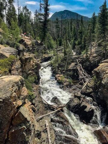
Adams Falls
Distance: .6 miles round trip
Elevation: 8400'
Trailhead location: The hike to Adams Falls begins from the East Inlet Trailhead near the town of Grand Lake on the west side of Rocky Mountain National Park. After turning into the Grand Lake area from Hwy 34 / Trail Ridge Road, drive three-tenths of a mile on West Portal Road until you reach a split in the road. Stay left at this junction and continue on West Portal Road for another 2 miles to reach the trailhead.
Trail Description: Head out on this 0.8-mile out-and-back trail near Grand Lake, Colorado. Generally considered an easy route, it takes an average of 20 min to complete. This is a very popular area for hiking and horseback riding, so you'll likely encounter other people while exploring. The best times to visit this trail are June through November. You'll need to leave pups at home — dogs aren't allowed on this trail
51 (рекомендации местных жителей)
Adams Falls
Adams Falls
Distance: .6 miles round trip
Elevation: 8400'
Trailhead location: The hike to Adams Falls begins from the East Inlet Trailhead near the town of Grand Lake on the west side of Rocky Mountain National Park. After turning into the Grand Lake area from Hwy 34 / Trail Ridge Road, drive three-tenths of a mile on West Portal Road until you reach a split in the road. Stay left at this junction and continue on West Portal Road for another 2 miles to reach the trailhead.
Trail Description: Head out on this 0.8-mile out-and-back trail near Grand Lake, Colorado. Generally considered an easy route, it takes an average of 20 min to complete. This is a very popular area for hiking and horseback riding, so you'll likely encounter other people while exploring. The best times to visit this trail are June through November. You'll need to leave pups at home — dogs aren't allowed on this trail