
Local places to see & visit
Food scene
This is the most local restaurant where you can get some local food. You can also enjoy a selection of freshly brewed teas.
This lovely restaurant is conveniently located across the road to the Rose Gardens, a must visit!
Restaurant & Tea House Roseiral
93 Estrada Regional 101This is the most local restaurant where you can get some local food. You can also enjoy a selection of freshly brewed teas.
This lovely restaurant is conveniently located across the road to the Rose Gardens, a must visit!
Sightseeing
The Queimadas Forest Park offers the opportunity to observe the Laurissilva Forest and has a picnic area.
Located in the municipality of Santana, here you can observe the Laurissilva Forest flora.
This park offers a forest shelter a construction which resembles the typical houses of Santana, such as its unique thatched roof.
At the Queimadas Forest park you can engage several walking trails along the streams and paths that lead to different points on the island, particularly the PR 9 - Levada do Caldeirão Verde (Queimadas - Caldeirão Verde - Caldeirão do Inferno) and the footpath that gives access to Pico das Pedras.
15 (рекомендации местных жителей)
Парк Кеймадас
Levada do Caldeirão VerdeThe Queimadas Forest Park offers the opportunity to observe the Laurissilva Forest and has a picnic area.
Located in the municipality of Santana, here you can observe the Laurissilva Forest flora.
This park offers a forest shelter a construction which resembles the typical houses of Santana, such as its unique thatched roof.
At the Queimadas Forest park you can engage several walking trails along the streams and paths that lead to different points on the island, particularly the PR 9 - Levada do Caldeirão Verde (Queimadas - Caldeirão Verde - Caldeirão do Inferno) and the footpath that gives access to Pico das Pedras.
This trail of 2,8km and duration of 1.30 hours allows you to get to the highest summit of the island, Pico Ruivo.
Beginning at Achada do Teixeira this trail climbs up to the island’s highest peak, Pico Ruivo (1862 m).
Next to the Pico Ruivo government house you can gain access to 3 other trails that take the hiker to different parts of the island: PR 1 - Pico do Areeiro footpath (5,1/6,4 Km), which takes you to Pico do Areeiro, the island’s 2nd highest peak (1816m); PR 1.3 - Encumeada Footpath (8.6 Km), goes along the central mountain range to the West; and PR 1.1- Ilha Footpath (8.2 Km), which descends to the parish of Ilha. Along the climb you will meet several shelters as the change in climate is sudden and sharp and the area often becomes covered in a sea of clouds or rests above it.
This area is part of the European network of important areas - Natura 2000 - and is known as the central mountain massif. It covers from the highest peaks to 1200m above sea level. It is characterised by herbaceous and bush vegetation that is well-adapted to big temperature variations, heavy rains and strong winds, and is where you can find many types of heather (Erica scoparia ssp maderensis and Erica aborea), which many years ago were used to produce charcoal.
The trail climbs along the ridge that separates the cliffs of Faial and those of Santana, and so allows for an excellent view to the left of the Ribeira Seca valley, topped by Pico das Torres, and Pico do Areeiro in the background.
On the right-hand side you can see the “gables” of the Santana mountain range, from where in the distance you can see the Queimadas Forest Park and further ahead Achada do Marques (a small hamlet known for its straw lofts and traditional fields), which appears in the centre of the Ribeira dos Arcos valley. T
owards the interior we can see the Ribeira Grande valley that begins at the “mouths” of Caldeirão Verde and Caldeirão do Inferno.
When visibility is good to the East you can see the rocky outcrop of Penha d’Águia, the Funduras mountain range and part of the S. Lourenço Point (far eastern part of Madeira island).
At Achada do Teixeira you can also visit the “Standing Man” (“Homem em pé”), a basalt formation which you will find walking down the cliff, after passing the Achada do Teixeira government house.
13 (рекомендации местных жителей)
PR1.2 Vereda do Pico Ruivo
Achada do TeixeiraThis trail of 2,8km and duration of 1.30 hours allows you to get to the highest summit of the island, Pico Ruivo.
Beginning at Achada do Teixeira this trail climbs up to the island’s highest peak, Pico Ruivo (1862 m).
Next to the Pico Ruivo government house you can gain access to 3 other trails that take the hiker to different parts of the island: PR 1 - Pico do Areeiro footpath (5,1/6,4 Km), which takes you to Pico do Areeiro, the island’s 2nd highest peak (1816m); PR 1.3 - Encumeada Footpath (8.6 Km), goes along the central mountain range to the West; and PR 1.1- Ilha Footpath (8.2 Km), which descends to the parish of Ilha. Along the climb you will meet several shelters as the change in climate is sudden and sharp and the area often becomes covered in a sea of clouds or rests above it.
This area is part of the European network of important areas - Natura 2000 - and is known as the central mountain massif. It covers from the highest peaks to 1200m above sea level. It is characterised by herbaceous and bush vegetation that is well-adapted to big temperature variations, heavy rains and strong winds, and is where you can find many types of heather (Erica scoparia ssp maderensis and Erica aborea), which many years ago were used to produce charcoal.
The trail climbs along the ridge that separates the cliffs of Faial and those of Santana, and so allows for an excellent view to the left of the Ribeira Seca valley, topped by Pico das Torres, and Pico do Areeiro in the background.
On the right-hand side you can see the “gables” of the Santana mountain range, from where in the distance you can see the Queimadas Forest Park and further ahead Achada do Marques (a small hamlet known for its straw lofts and traditional fields), which appears in the centre of the Ribeira dos Arcos valley. T
owards the interior we can see the Ribeira Grande valley that begins at the “mouths” of Caldeirão Verde and Caldeirão do Inferno.
When visibility is good to the East you can see the rocky outcrop of Penha d’Águia, the Funduras mountain range and part of the S. Lourenço Point (far eastern part of Madeira island).
At Achada do Teixeira you can also visit the “Standing Man” (“Homem em pé”), a basalt formation which you will find walking down the cliff, after passing the Achada do Teixeira government house.
The Núcleo of Casas Típicas de Santana presents some typical houses of Santana, where it is also possible to purchase some regional products.
Located next to the Municipality of Santana, the Nucleus of Typical Houses of Santana constitutes a preservation space, expanded by the Municipality of Santana, in memory of the local heritage.
Here are arranged some typical houses of Santana, all of them adapted to the current context, in which it is also possible to purchase a wide variety of local, handmade and traditional products.
22 (рекомендации местных жителей)
Типичные дома Сантаны
The Núcleo of Casas Típicas de Santana presents some typical houses of Santana, where it is also possible to purchase some regional products.
Located next to the Municipality of Santana, the Nucleus of Typical Houses of Santana constitutes a preservation space, expanded by the Municipality of Santana, in memory of the local heritage.
Here are arranged some typical houses of Santana, all of them adapted to the current context, in which it is also possible to purchase a wide variety of local, handmade and traditional products.
Beginning in the Queimadas Forestry Park, this walk is ‘out-and-back’, and crosses some spectacularly steep slopes, but is one of the finest ways of penetrating the deep valley of the São Jorge brook on foot; you’ll need a torch on this walk, which passes through a tunnel.
This trail begins at the Queimadas Forestry Park and winds along the walkway of the levada of Caldeirão Verde at 980 m elevation, in the municipality of Santana.
The levada of Caldeirão Verde is an impressive work of art built in the 18th century that begins in the main stream bed of the Caldeirão Verde brook. Passing through steep cliffs and mountains, it carries the water that runs off the highest mountains of Madeira, to be used to irrigate the farm lands of the parish of Faial.
This levada is used for agricultural purposes, but it is also an important means of reaching the interior of the deep valley of the São Jorge brook on foot, offering the traveler a spectacular view of the mountainous terrain of the interior of the island and the opportunity to walk through tunnels carved by hand out of the rock.
At the Queimadas Forestry Park there is a shelter (Casa de Abrigo das Queimadas), which retains the original features of the typical houses of Santana, including a marvelous thatched roof.
Worthy of mention are the excellent specimens of elegant Japanese cedars (Cryptomeria japonica), European beech (Fagus sylvatica) with their dense reddish foliage, Canary Island junipers (Juniperus cedrus), Madeira laurel (Ocotea foetens), Pau branco or southern olive (Picconia excelsa), hundred-year-old broom heath (Erica scoparia) as well as some specimens of lily-of-the-valley tree (Clethra arborea), and Madeira blueberry (Vaccinium padifolium), which can be seen along the trail.
Species of indigenous avifauna that can be seen include the chaffinch (Frigila coelebs), the firecrest (Regulus ignicapillus madeirensis), the Madeira long-toed pigeon (Columba trocaz trocaz), grey wagtail (Motacilla cinerea schmitzi), and the buzzard (Buteo buteo harteti).
Close to the Queimadas Park one can see off to the side a small settlement called Achada do Marques, a site that has been designated as Protected landscape, noted for its traditional farm terraces and old stone cow huts.
After you pass through the 4 tunnels on the route, Caldeirão Verde appears on the left of the levada.
The Caldeirão Verde lake is formed by water that falls from the bed of the Caldeirão Verde stream bed from a height of approximately 100m.
Indulge yourself and revel in the surrounding scenery and catch your breath for the return trip.
19 (рекомендации местных жителей)
PR9 Левада Зеленого Котла
Beginning in the Queimadas Forestry Park, this walk is ‘out-and-back’, and crosses some spectacularly steep slopes, but is one of the finest ways of penetrating the deep valley of the São Jorge brook on foot; you’ll need a torch on this walk, which passes through a tunnel.
This trail begins at the Queimadas Forestry Park and winds along the walkway of the levada of Caldeirão Verde at 980 m elevation, in the municipality of Santana.
The levada of Caldeirão Verde is an impressive work of art built in the 18th century that begins in the main stream bed of the Caldeirão Verde brook. Passing through steep cliffs and mountains, it carries the water that runs off the highest mountains of Madeira, to be used to irrigate the farm lands of the parish of Faial.
This levada is used for agricultural purposes, but it is also an important means of reaching the interior of the deep valley of the São Jorge brook on foot, offering the traveler a spectacular view of the mountainous terrain of the interior of the island and the opportunity to walk through tunnels carved by hand out of the rock.
At the Queimadas Forestry Park there is a shelter (Casa de Abrigo das Queimadas), which retains the original features of the typical houses of Santana, including a marvelous thatched roof.
Worthy of mention are the excellent specimens of elegant Japanese cedars (Cryptomeria japonica), European beech (Fagus sylvatica) with their dense reddish foliage, Canary Island junipers (Juniperus cedrus), Madeira laurel (Ocotea foetens), Pau branco or southern olive (Picconia excelsa), hundred-year-old broom heath (Erica scoparia) as well as some specimens of lily-of-the-valley tree (Clethra arborea), and Madeira blueberry (Vaccinium padifolium), which can be seen along the trail.
Species of indigenous avifauna that can be seen include the chaffinch (Frigila coelebs), the firecrest (Regulus ignicapillus madeirensis), the Madeira long-toed pigeon (Columba trocaz trocaz), grey wagtail (Motacilla cinerea schmitzi), and the buzzard (Buteo buteo harteti).
Close to the Queimadas Park one can see off to the side a small settlement called Achada do Marques, a site that has been designated as Protected landscape, noted for its traditional farm terraces and old stone cow huts.
After you pass through the 4 tunnels on the route, Caldeirão Verde appears on the left of the levada.
The Caldeirão Verde lake is formed by water that falls from the bed of the Caldeirão Verde stream bed from a height of approximately 100m.
Indulge yourself and revel in the surrounding scenery and catch your breath for the return trip.
One of the closest Levadas to Casa Nobrega. In the northern part of the island, this route is linear but makes a return by the outward route. There are tunnels on this walk, for which a torch is essential. The first part of the trail follows the levada through an afforested area, but offers spectacular views of the São Jorge and Santana farmlands.
The trail that follows alongside the Levada do Rei begins at the Water Treatment Plant at Quebradas in São Jorge, ending at the source of the levada in the spectacular Ribeiro Bonito stream.
The first part of the trail crosses a forested area where some specimens of indigenous vegetation are found here and there. This initial leg of the trail presents travellers with beautiful panoramic views of the São Jorge and Santana farmlands. After the midway point of the trail, the levada that winds from the interior of the island along the mountain slopes passes through a spectacular area of native forest which is well developed and rich in natural biodiversity.
The tunnels formed by the luxuriant vegetation and the great variety of species that you can find here are excellent living examples of the potential of nature, while the beautiful levada is evidence of the valuable cultural heritage of the island.
The path ends at Ribeiro Bonito, where you are aware of feeling you are in a true sanctuary of nature. This is one of the areas of the Laurisilva forest - World Nature Heritage of UNESCO since 1999, where the genuinely Madeiran vegetation reaches its highest expression and its location and isolation leave one with the sensation of having gone back in time to the discovery of the island.
The permanent presence of clear water in this location intensifies the abundant life forms here and allows a great diversity of species to thrive. You can take delight in the majestic centenary Madeira laurels (Ocotea foetens), the laurel trees (Laurus novocanariensis), the Madeira mahogany (Persea indica), and in the tiny birds like the firecrest (Rugulus ignicapillus maderensis), and the chaffinch (Fringilla coelebs maderensis), species that bring vitality to this ecosystem and please the ear with their songs.
Be sure to visit the São Jorge water mill (moínho), which is about three hundred years old. This mill is a good example of preservation, and powered by the water from the Levada do Rei, it grinds wheat, maize, barley and rye grown on the terraces of São Jorge.
16 (рекомендации местных жителей)
PR18 Levada Do Rei
One of the closest Levadas to Casa Nobrega. In the northern part of the island, this route is linear but makes a return by the outward route. There are tunnels on this walk, for which a torch is essential. The first part of the trail follows the levada through an afforested area, but offers spectacular views of the São Jorge and Santana farmlands.
The trail that follows alongside the Levada do Rei begins at the Water Treatment Plant at Quebradas in São Jorge, ending at the source of the levada in the spectacular Ribeiro Bonito stream.
The first part of the trail crosses a forested area where some specimens of indigenous vegetation are found here and there. This initial leg of the trail presents travellers with beautiful panoramic views of the São Jorge and Santana farmlands. After the midway point of the trail, the levada that winds from the interior of the island along the mountain slopes passes through a spectacular area of native forest which is well developed and rich in natural biodiversity.
The tunnels formed by the luxuriant vegetation and the great variety of species that you can find here are excellent living examples of the potential of nature, while the beautiful levada is evidence of the valuable cultural heritage of the island.
The path ends at Ribeiro Bonito, where you are aware of feeling you are in a true sanctuary of nature. This is one of the areas of the Laurisilva forest - World Nature Heritage of UNESCO since 1999, where the genuinely Madeiran vegetation reaches its highest expression and its location and isolation leave one with the sensation of having gone back in time to the discovery of the island.
The permanent presence of clear water in this location intensifies the abundant life forms here and allows a great diversity of species to thrive. You can take delight in the majestic centenary Madeira laurels (Ocotea foetens), the laurel trees (Laurus novocanariensis), the Madeira mahogany (Persea indica), and in the tiny birds like the firecrest (Rugulus ignicapillus maderensis), and the chaffinch (Fringilla coelebs maderensis), species that bring vitality to this ecosystem and please the ear with their songs.
Be sure to visit the São Jorge water mill (moínho), which is about three hundred years old. This mill is a good example of preservation, and powered by the water from the Levada do Rei, it grinds wheat, maize, barley and rye grown on the terraces of São Jorge.
These ruins, which are located in the Calhau de São Jorge, belong to the old sugar cane mills that were built there at the beginning of the island's settlement.
In the pebble of São Jorge we find the Primitive Nucleus of the parish of São Jorge. Of the old constructions, the entrance portico of the pebble is one of the most significant.
This entire nucleus has been classified as a Monument of Municipal Interest since 2003.
6 (рекомендации местных жителей)
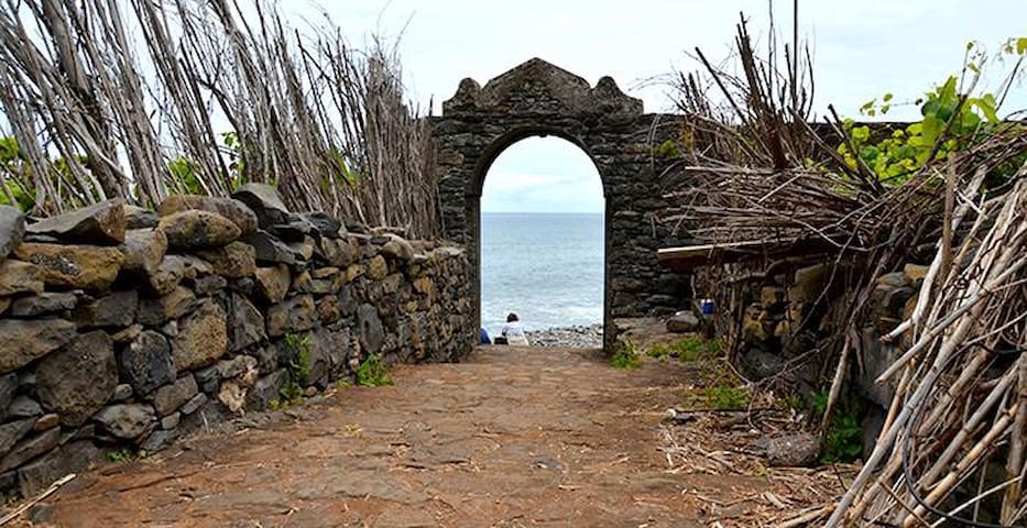
Руины Святого Георга
These ruins, which are located in the Calhau de São Jorge, belong to the old sugar cane mills that were built there at the beginning of the island's settlement.
In the pebble of São Jorge we find the Primitive Nucleus of the parish of São Jorge. Of the old constructions, the entrance portico of the pebble is one of the most significant.
This entire nucleus has been classified as a Monument of Municipal Interest since 2003.
Swimming Nearby
The Foz da Ribeira do Faial Bathing Complex, which has a natural swimming pool, has several leisure spaces and support infrastructures. The Foz da Ribeira do Faial Bathing Complex, located on the north coast of the island of Madeira, is a small beach of pebble that has a natural pool.
This beach has several leisure spaces such as a playground with a sand floor suitable for hosting international football, handball and beach volleyball championships, a multi-sports pavilion, a salt water children's pool and a children's playground.
This beach also has a restaurant area, changing rooms, first aid and a vast solarium. Close to this beach, you will also find a karting track reserved for lovers of motor sports.
Complexo Balnear da Foz da Ribeira do Faial
The Foz da Ribeira do Faial Bathing Complex, which has a natural swimming pool, has several leisure spaces and support infrastructures. The Foz da Ribeira do Faial Bathing Complex, located on the north coast of the island of Madeira, is a small beach of pebble that has a natural pool.
This beach has several leisure spaces such as a playground with a sand floor suitable for hosting international football, handball and beach volleyball championships, a multi-sports pavilion, a salt water children's pool and a children's playground.
This beach also has a restaurant area, changing rooms, first aid and a vast solarium. Close to this beach, you will also find a karting track reserved for lovers of motor sports.
It offers two salt water swimming pools, solarium, gardens, changing rooms, bar / terrace and first aid services, surveillance and parking.
The Ponta Delgada Bathing Complex, located next to the parish's main church, consists of two swimming pools, one for adults and one for children, both fed by salt water and has a water treatment system.
It also has a large solarium area, bar / terrace, changing rooms and first aid services.
Due to the construction of the rockfill it was possible to create a beach in a small protected bay.
Access is paid
11 (рекомендации местных жителей)
Piscina de Ponta Delgada
ER101It offers two salt water swimming pools, solarium, gardens, changing rooms, bar / terrace and first aid services, surveillance and parking.
The Ponta Delgada Bathing Complex, located next to the parish's main church, consists of two swimming pools, one for adults and one for children, both fed by salt water and has a water treatment system.
It also has a large solarium area, bar / terrace, changing rooms and first aid services.
Due to the construction of the rockfill it was possible to create a beach in a small protected bay.
Access is paid
Things to do
The Kartódromo do Faial (Karting) has a 1040 meter wide track, with several technical areas, straight and curved, offering you moments of pure adrenaline, surrounded by a magnificent landscape.
The Kartódromo do Faial is located in one of the most beautiful coves in Madeira, located in the North of the island, next to Santana. The 1040 meter track has an extremely attractive layout, with several straight lines and fast curves interspersed with technical zones of sharp curves. The track is wide and surrounded by lawns, ideal for overtaking, which provides good emotions and adrenaline.
The Kartódromo do Faial is an excellent choice for fun moments with friends, as in addition to official competitions it is also possible to organize private races on the spot. created among all participants and are enhanced by the delivery of trophies and certificates of attendance.
The Kartódromo do Faial also has resistance tests and a karting school for the youngest to learn this discipline. This beach also has a restaurant area, changing rooms, first aid and a vast solarium. Close to this beach, you will also find a karting track reserved for lovers of motor sports.
Pista de Karting
ER101The Kartódromo do Faial (Karting) has a 1040 meter wide track, with several technical areas, straight and curved, offering you moments of pure adrenaline, surrounded by a magnificent landscape.
The Kartódromo do Faial is located in one of the most beautiful coves in Madeira, located in the North of the island, next to Santana. The 1040 meter track has an extremely attractive layout, with several straight lines and fast curves interspersed with technical zones of sharp curves. The track is wide and surrounded by lawns, ideal for overtaking, which provides good emotions and adrenaline.
The Kartódromo do Faial is an excellent choice for fun moments with friends, as in addition to official competitions it is also possible to organize private races on the spot. created among all participants and are enhanced by the delivery of trophies and certificates of attendance.
The Kartódromo do Faial also has resistance tests and a karting school for the youngest to learn this discipline. This beach also has a restaurant area, changing rooms, first aid and a vast solarium. Close to this beach, you will also find a karting track reserved for lovers of motor sports.
Formed by an old recovered cellar, it is possible to appreciate in this museum the utensils used over time in the production of regional wine.
The "Museum of Vine and Wine" is located in the Experimental Viticulture Field of Arco de São Jorge, in the municipality of Santana. The museum, which aims to be a living and interactive space, consists of an old cellar, recovered with utensils used in viticulture, mostly provided by the local population, and an experimental field.
In the cellar, three mills were recovered and, in an adjacent area, a space was created for tasting various regional products, such as the honey cake and various traditional breads.
In addition to the wines, mills and instruments used over the decades for the production of wine, the visitor can observe, live, the various cycles of the vineyard, as well as an explanation of the characteristics of the different cultivated varieties.
Outside, visitors can enjoy Laurissilva's gardens, shrubs and trees and leisure and rest spaces that provide contact with the natural resources of the parish.
The space also includes a «Sweets and Traditions» store that sells homemade bread, cakes and honey cakes and wicker pieces.
Museu do Vinho e da Vinha
Formed by an old recovered cellar, it is possible to appreciate in this museum the utensils used over time in the production of regional wine.
The "Museum of Vine and Wine" is located in the Experimental Viticulture Field of Arco de São Jorge, in the municipality of Santana. The museum, which aims to be a living and interactive space, consists of an old cellar, recovered with utensils used in viticulture, mostly provided by the local population, and an experimental field.
In the cellar, three mills were recovered and, in an adjacent area, a space was created for tasting various regional products, such as the honey cake and various traditional breads.
In addition to the wines, mills and instruments used over the decades for the production of wine, the visitor can observe, live, the various cycles of the vineyard, as well as an explanation of the characteristics of the different cultivated varieties.
Outside, visitors can enjoy Laurissilva's gardens, shrubs and trees and leisure and rest spaces that provide contact with the natural resources of the parish.
The space also includes a «Sweets and Traditions» store that sells homemade bread, cakes and honey cakes and wicker pieces.