
Conservation Areas, Trails and Hiking
Conservation Area
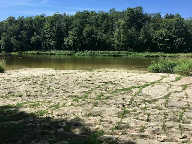
The Bannockburn Conservation Area is located on Bannockburn Line (east of Varna). Early morning walks will reward you with sightings of deer, grouse and numerous song birds, Bannockburn is home to six different natural communities:
Wet Meadow, White Cedar, Deciduous Forest, March, Old Field and Aquatic.
Download audio guidelines are available.
Hunting and motorized vehicles are not permitted.
Partially wheelchair accessible.
DISTANCE - 1.9 Kms
DIFFICULTY LEVEL - Level 3 some hills, natural path
TRAIL USE - Walking, Pets on leash, Wheelchair access (some sections)
TRAIL HAZARDS - None evident
TRAIL SURFACE - Natural surface, some boardwalks, stairs
COST FOR USING TRAIL - Donations accepted by Ausable Bayfield Conservation Authority
DRIVING DIRECTIONS - Located on 76249 Bannockburn Line - 1st side road east of Varna off County Rd #3 (Mill Road)
12 (рекомендации местных жителей)
Bannockburn Conservation Area
76249 Bannockburn LineThe Bannockburn Conservation Area is located on Bannockburn Line (east of Varna). Early morning walks will reward you with sightings of deer, grouse and numerous song birds, Bannockburn is home to six different natural communities:
Wet Meadow, White Cedar, Deciduous Forest, March, Old Field and Aquatic.
Download audio guidelines are available.
Hunting and motorized vehicles are not permitted.
Partially wheelchair accessible.
DISTANCE - 1.9 Kms
DIFFICULTY LEVEL - Level 3 some hills, natural path
TRAIL USE - Walking, Pets on leash, Wheelchair access (some sections)
TRAIL HAZARDS - None evident
TRAIL SURFACE - Natural surface, some boardwalks, stairs
COST FOR USING TRAIL - Donations accepted by Ausable Bayfield Conservation Authority
DRIVING DIRECTIONS - Located on 76249 Bannockburn Line - 1st side road east of Varna off County Rd #3 (Mill Road)
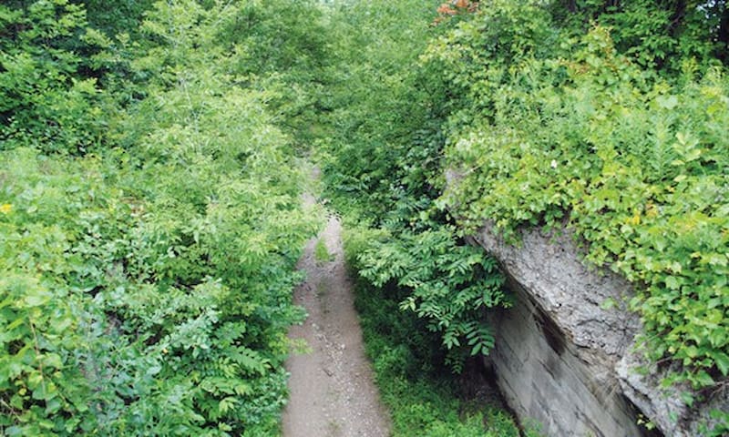
Cedar Lowlands and Hemlock Forest
In an area highlighted by a scenic 3 km trail loop. The trail crosses the Belgrave Creek, passes through meadows with hedgerow plantings and down a steep hill to the cedar lowlands at the river.
A boardwalk leads through the hemlock forest to the upland hardwoods or red pin plantation. Follow the edge of the forest back to the parking lot area.
DISTANCE - 3 km loop
DIFFICULTY LEVEL - Level 2 - moderate
TRAIL USE - Walking, Skiing, Pets on leash
TRAIL HAZARDS - Poison ivy along the creek and river. Trail west of Nature Centre, bridge out November - May.
TRAIL SURFACE - Natural surface, some boardwalks
COST FOR TRAIL USE - None
DRIVING DIRECTIONS - County Rd #3. North of Blyth to Nature Centre Road, left (west). About 7 km on right.
Wawanosh Valley Conservation Education Centre
38854 Nature CentreCedar Lowlands and Hemlock Forest
In an area highlighted by a scenic 3 km trail loop. The trail crosses the Belgrave Creek, passes through meadows with hedgerow plantings and down a steep hill to the cedar lowlands at the river.
A boardwalk leads through the hemlock forest to the upland hardwoods or red pin plantation. Follow the edge of the forest back to the parking lot area.
DISTANCE - 3 km loop
DIFFICULTY LEVEL - Level 2 - moderate
TRAIL USE - Walking, Skiing, Pets on leash
TRAIL HAZARDS - Poison ivy along the creek and river. Trail west of Nature Centre, bridge out November - May.
TRAIL SURFACE - Natural surface, some boardwalks
COST FOR TRAIL USE - None
DRIVING DIRECTIONS - County Rd #3. North of Blyth to Nature Centre Road, left (west). About 7 km on right.
The trail offers hiking in a beautiful natural setting along the Maitland River. The trail starts from the entrance parking lot, follows the road past the fish pond to the start of the trail. Leads down the steep hill behind the wind mill and follows the wide shallow river to the scenic Benmiller Falls.
DISTANCE - 3.2 km loop
DIFFICULTY LEVEL - Level 2 (moderate) and Level 3 (some hills, natural path)
TRAIL USE - Walking, Skiing, pets on leash
TRAIL HAZARDS - Poison ivy along the river
TRAIL SURFACE - Natural surface, Groom ski trail (winter)
COST OF USING TRAIL - Day use fees posted at gatehouse
DRIVING DIRECTIONS - From Goderich go 6 km east on Highway #8 to County Rd #1, turn left to Benmiller then follow the signs. The Falls Reserve is located just west of Benmiller, off County Rd #31
12 (рекомендации местных жителей)
Falls Reserve Conservation Area
80900 Falls Reserve LineThe trail offers hiking in a beautiful natural setting along the Maitland River. The trail starts from the entrance parking lot, follows the road past the fish pond to the start of the trail. Leads down the steep hill behind the wind mill and follows the wide shallow river to the scenic Benmiller Falls.
DISTANCE - 3.2 km loop
DIFFICULTY LEVEL - Level 2 (moderate) and Level 3 (some hills, natural path)
TRAIL USE - Walking, Skiing, pets on leash
TRAIL HAZARDS - Poison ivy along the river
TRAIL SURFACE - Natural surface, Groom ski trail (winter)
COST OF USING TRAIL - Day use fees posted at gatehouse
DRIVING DIRECTIONS - From Goderich go 6 km east on Highway #8 to County Rd #1, turn left to Benmiller then follow the signs. The Falls Reserve is located just west of Benmiller, off County Rd #31
Naftel's Creek Conservation Area Trail Leads through mixed conifer plantations, hardwood and wetland areas. Boardwalks allow visitors to enjoy the wetland. Watch for trout as you cross the Naftel's Creek. Note - there are many side trails.
In the winter Naftel's Creek Conservation Area is a popular trail for cross country skiing. Three side trails and a common trail covering 49 hectares of beautiful forests.
DISTANCE - 3.2 km loop
DIFFICULTY LEVEL - Level 2 moderate
TRAIL USE - Walking, Skiing, Pets on Leash
TRAIL HAZARDS - Poison Ivy in wet areas, steep hill on blue trail
TRAIL SURFACE - Natural surface, some boardwalks
COST FOR USING TRAIL - None
DRIVING DIRECTIONS - Located about 7 km south of Goderich on Hwy #21. Parking is available just off Hwy #21 at the trail access point - #79152. Between Union Rd and Kitchigami Rd.
9 (рекомендации местных жителей)
Naftel's Creek Conservation Area
79154 Bluewater HighwayNaftel's Creek Conservation Area Trail Leads through mixed conifer plantations, hardwood and wetland areas. Boardwalks allow visitors to enjoy the wetland. Watch for trout as you cross the Naftel's Creek. Note - there are many side trails.
In the winter Naftel's Creek Conservation Area is a popular trail for cross country skiing. Three side trails and a common trail covering 49 hectares of beautiful forests.
DISTANCE - 3.2 km loop
DIFFICULTY LEVEL - Level 2 moderate
TRAIL USE - Walking, Skiing, Pets on Leash
TRAIL HAZARDS - Poison Ivy in wet areas, steep hill on blue trail
TRAIL SURFACE - Natural surface, some boardwalks
COST FOR USING TRAIL - None
DRIVING DIRECTIONS - Located about 7 km south of Goderich on Hwy #21. Parking is available just off Hwy #21 at the trail access point - #79152. Between Union Rd and Kitchigami Rd.
Area is located on the south side of Clinton. The trail offers a pleasant walk along the Bayfield River and through the Commemorative Woods site.
Exercise stations are available along the trail system.
A picnic pavilion provides shelter and playground facilities are also available.
DISTANCE - 2 km loop
DIFFICULTY LEVEL - Level 1 easy
TRAIL USE - Walking, skiing, pets on leash, some wheelchair access
TRAIL HAZARDS - None evident
TRAIL SURFACE - Natural surface
COST FOR USING TRAIL - Donations accepted by the Lions Club or Ausable Bayfield Conservation Authority
DRIVING DIRECTIONS - Located on Hwy #4, south of Clinton, next to Highway bridge.
Clinton Conservation Area
77800 ON-4Area is located on the south side of Clinton. The trail offers a pleasant walk along the Bayfield River and through the Commemorative Woods site.
Exercise stations are available along the trail system.
A picnic pavilion provides shelter and playground facilities are also available.
DISTANCE - 2 km loop
DIFFICULTY LEVEL - Level 1 easy
TRAIL USE - Walking, skiing, pets on leash, some wheelchair access
TRAIL HAZARDS - None evident
TRAIL SURFACE - Natural surface
COST FOR USING TRAIL - Donations accepted by the Lions Club or Ausable Bayfield Conservation Authority
DRIVING DIRECTIONS - Located on Hwy #4, south of Clinton, next to Highway bridge.
Early morning walks will reward you with sightings of deer, grouse and numerous song birds. Bannockburn is home to six different natural communities: wet meadow, white cedar, deciduous forest march, old field and aquatic.
DISTANCE - 1.9 kms
DIFFICULTY LEVEL - Level 3 - some hills and natural path
TRAIL USE - walking, pets on leash, wheelchair access (some sections)
TRAIL HAZARDS - None evident
TRAIL SURFACE - Natural surface, some boardwalks, stairs
COST FOR USING TRAIL - Donations accepted by Ausable Bayfield Conservation Authority
DRIVING DIRECTIONS - Located on 76249 Bannockburn Line - 1st side road east of Varna off County Rd. #3 (Mill Road)
12 (рекомендации местных жителей)
Bannockburn Conservation Area
76249 Bannockburn LineEarly morning walks will reward you with sightings of deer, grouse and numerous song birds. Bannockburn is home to six different natural communities: wet meadow, white cedar, deciduous forest march, old field and aquatic.
DISTANCE - 1.9 kms
DIFFICULTY LEVEL - Level 3 - some hills and natural path
TRAIL USE - walking, pets on leash, wheelchair access (some sections)
TRAIL HAZARDS - None evident
TRAIL SURFACE - Natural surface, some boardwalks, stairs
COST FOR USING TRAIL - Donations accepted by Ausable Bayfield Conservation Authority
DRIVING DIRECTIONS - Located on 76249 Bannockburn Line - 1st side road east of Varna off County Rd. #3 (Mill Road)
Community Trail
Runs from east to west, meandering along the old abandoned rail bed, crossing the Maitland River and then it makes a loop around the Turnberry Flood Plan Conservation Area to take you back.
Several benches are placed along the trail on the east side of the river. A covered gazebo is at the east end of the trail. Enjoy the scenic view of the river from the old CNR bridge, the natural growth and plantings along the trail.
DISTANCE - 2.5 km loop
DIFFICULTY LEVEL - Level 1 - easy (good for young children) east side of river, Level 3 - some hills, natural path, west side of river
TRAIL USE - Walking, Cycling, Skiing, Wheelchair Accessible, Pets on leash
TRAIL HAZARDS - None evident
TRAIL SURFACE - Paved/brick, natural surface, recycled plastic decking on bridge
COST FOR USING TRAIL - None
DRIVING DIRECTIONS - Several trail access points. The trail crossed Josephine Street, near the railway tracks
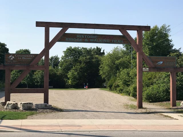
Wingham Community Trail
Wingham Community TrailRuns from east to west, meandering along the old abandoned rail bed, crossing the Maitland River and then it makes a loop around the Turnberry Flood Plan Conservation Area to take you back.
Several benches are placed along the trail on the east side of the river. A covered gazebo is at the east end of the trail. Enjoy the scenic view of the river from the old CNR bridge, the natural growth and plantings along the trail.
DISTANCE - 2.5 km loop
DIFFICULTY LEVEL - Level 1 - easy (good for young children) east side of river, Level 3 - some hills, natural path, west side of river
TRAIL USE - Walking, Cycling, Skiing, Wheelchair Accessible, Pets on leash
TRAIL HAZARDS - None evident
TRAIL SURFACE - Paved/brick, natural surface, recycled plastic decking on bridge
COST FOR USING TRAIL - None
DRIVING DIRECTIONS - Several trail access points. The trail crossed Josephine Street, near the railway tracks
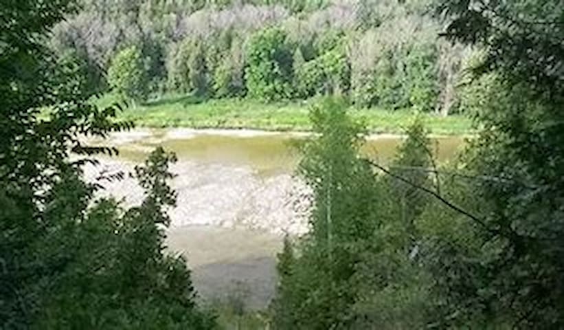
The Maitland Trail follows the north side of the Maitland River Valley.
Varied terrain from flat sections, gentle slopes to steep climbs. Hike along ridges to down along river flats. Sometimes rugged but many beautiful vistas and rewarding hiking.
A rich variety of plant and bird life can be seen. These trails offer walking, hiking and snow shoeing, plus skiing in some sections.
DISTANCE - 49 km with some optional side / blue loops
DIFFICULTY LEVEL - Levels 1 (easy), 2( moderate), 3 ( some hills and natural path), 4 (hilly - more experienced hikers). Conditions vary widely depending on section.
TRAIL USE - Waling, Skiing, Pets on Leash
TRAIL HAZARS - Some steep cliffs, if you stray off the trail, some road sections
TRAIL SURFACE - Natural surface
COST FOR USING TRAIL - None (end to end badges available for purchase)
DRIVING DIRECTIONS - Several access points - use trail app
The Maitland
25 North Harbour Rd EThe Maitland Trail follows the north side of the Maitland River Valley.
Varied terrain from flat sections, gentle slopes to steep climbs. Hike along ridges to down along river flats. Sometimes rugged but many beautiful vistas and rewarding hiking.
A rich variety of plant and bird life can be seen. These trails offer walking, hiking and snow shoeing, plus skiing in some sections.
DISTANCE - 49 km with some optional side / blue loops
DIFFICULTY LEVEL - Levels 1 (easy), 2( moderate), 3 ( some hills and natural path), 4 (hilly - more experienced hikers). Conditions vary widely depending on section.
TRAIL USE - Waling, Skiing, Pets on Leash
TRAIL HAZARS - Some steep cliffs, if you stray off the trail, some road sections
TRAIL SURFACE - Natural surface
COST FOR USING TRAIL - None (end to end badges available for purchase)
DRIVING DIRECTIONS - Several access points - use trail app
Trails
The development of this trail has been a community project including a walking trail, a fitness trail and a fish habitat improvement area.
The trail is situated on the former CPR rail line and runs adjacent to the Blyth Brook.
Along the trail, hikers will see wood duck nesting boxes as you enjoy the spectacular vista view of the countryside.
The trail ends at a unique stone arch bridge built by the Grand Trunk Railway. Parking is available just east of the bridge. The trail runs east and west of the bridge located on County Rd #4 in Blyth.
DISTANCE - 1.37 km with 0.46 km loop
DIFFICULTY LEVEL - Level 1 easy and Level 2 moderate
TRAIL USE - Walking, Cycling, Skiing, Wheelchair Accessible, Pets on leash
TRAIL HAZARDS - none evident
TRAIL SURFACE - natural surface, wood chips
COST FOR USING TRAIL - None
DRIVING DIRECTIONS - Blyth is located on County Road #4 (London Rd) half way between Clinton and Wingham
Blyth Greenway Trail
554 Queen StThe development of this trail has been a community project including a walking trail, a fitness trail and a fish habitat improvement area.
The trail is situated on the former CPR rail line and runs adjacent to the Blyth Brook.
Along the trail, hikers will see wood duck nesting boxes as you enjoy the spectacular vista view of the countryside.
The trail ends at a unique stone arch bridge built by the Grand Trunk Railway. Parking is available just east of the bridge. The trail runs east and west of the bridge located on County Rd #4 in Blyth.
DISTANCE - 1.37 km with 0.46 km loop
DIFFICULTY LEVEL - Level 1 easy and Level 2 moderate
TRAIL USE - Walking, Cycling, Skiing, Wheelchair Accessible, Pets on leash
TRAIL HAZARDS - none evident
TRAIL SURFACE - natural surface, wood chips
COST FOR USING TRAIL - None
DRIVING DIRECTIONS - Blyth is located on County Road #4 (London Rd) half way between Clinton and Wingham
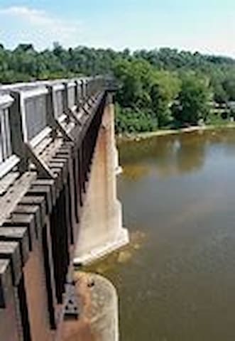
Starts at the former location of the CPR Station, at the Goderich Harbour (Harbour St.).It crosses behind the elevators to North Harbour road to the Menesetung Bridge where there is a magnificent view of the Maitland River.
The Menesetung Bridge was built as a Railway bridge in 1907.
Beyond the bridge it follows the abandoned CPR line to the Tomb of Tiger Dunlop, one of Huron County's colourful historical figures.
The blue Sifto Loop starts at the North end of the bridge, turning west, and features the Heritage Oak Tree.
The Menesetung Trail goes east of the Menesetung Bridge along the north side of the river.
DISTANCE 3.2 km linear - links to the Maitland Trail
DIFFICULTY LEVEL- Level 1 easy and Level 2 - Blue Trail
TRAIL USE - Walking, Cycling, Skiing, Pet on leach, Wheelchair Accessible (from North Harbour Road parking lot to Menesetung Bridge to below Tiger Dunlop's Tomb)
TRAIL HAZARDS - None evident
TRAIL SURFACE - Natural surfaces, stone dust, wookd planks on bridge
COST FOR USING TRAIL - None, donation box on site
DRIVING DIRECTIONS - Several entry points in Goderich
8 (рекомендации местных жителей)
Tiger Dunlop Heritage Trail
Goderich to Auburn Rail TrailStarts at the former location of the CPR Station, at the Goderich Harbour (Harbour St.).It crosses behind the elevators to North Harbour road to the Menesetung Bridge where there is a magnificent view of the Maitland River.
The Menesetung Bridge was built as a Railway bridge in 1907.
Beyond the bridge it follows the abandoned CPR line to the Tomb of Tiger Dunlop, one of Huron County's colourful historical figures.
The blue Sifto Loop starts at the North end of the bridge, turning west, and features the Heritage Oak Tree.
The Menesetung Trail goes east of the Menesetung Bridge along the north side of the river.
DISTANCE 3.2 km linear - links to the Maitland Trail
DIFFICULTY LEVEL- Level 1 easy and Level 2 - Blue Trail
TRAIL USE - Walking, Cycling, Skiing, Pet on leach, Wheelchair Accessible (from North Harbour Road parking lot to Menesetung Bridge to below Tiger Dunlop's Tomb)
TRAIL HAZARDS - None evident
TRAIL SURFACE - Natural surfaces, stone dust, wookd planks on bridge
COST FOR USING TRAIL - None, donation box on site
DRIVING DIRECTIONS - Several entry points in Goderich
Serene trail on the south edge of Goderich. Rich in its variety of trees, plant life and birds. Includes creeks and ponds.
Boardwalks are in place in the wet areas to protect the plant life. Trail offers walking, hiking and skiing in some sections. Pets, on leash allowed.
DISTANCE - 3.3 km with shorter loop options
DIFFICULTY LEVEL - Level 1 easy
TRAIL USE - Walking, Skiing, Hiking
TRAIL HAZARDS - Poison Ivy in area near Huckins St. Entrance
TRAIL SURFACE - Natural surface, boardwalks and gravel surface in wet areas
COST FOR USING TRAIL - None
DRIVING DIRECTIONS - Main entrance off Parsons Court at the Columbus Centre. Alternative entrance at the end of Huckins St, Bayfield Road south (Hwy #21), just pas Suncoast Mall, take Huckins St., trail entrance at the end of the street. Walk in trail entrance beside Fire Hall.
Maitland Woods
390 Parsons CtSerene trail on the south edge of Goderich. Rich in its variety of trees, plant life and birds. Includes creeks and ponds.
Boardwalks are in place in the wet areas to protect the plant life. Trail offers walking, hiking and skiing in some sections. Pets, on leash allowed.
DISTANCE - 3.3 km with shorter loop options
DIFFICULTY LEVEL - Level 1 easy
TRAIL USE - Walking, Skiing, Hiking
TRAIL HAZARDS - Poison Ivy in area near Huckins St. Entrance
TRAIL SURFACE - Natural surface, boardwalks and gravel surface in wet areas
COST FOR USING TRAIL - None
DRIVING DIRECTIONS - Main entrance off Parsons Court at the Columbus Centre. Alternative entrance at the end of Huckins St, Bayfield Road south (Hwy #21), just pas Suncoast Mall, take Huckins St., trail entrance at the end of the street. Walk in trail entrance beside Fire Hall.
Dramatic Vistas, intimate woods and expansive floodplain, all couched on the southern bank of the Maitland River Valley. Highway 21 to Nelson Street Access - this challenging section is sculpted into the most precipitous face of the river valley and affords an unusual view of some river rapids.
Nelson Street to Mill Road - this more moderate section descends into the Proudfoot Historical Tract and the extensive Maitland River Valley flood plain.
Proceeding upriver, enjoy the panorama of the valley before climbing to the top of the river bank.
DISTANCE & DIFFICULTY LEVEL - Hwy #21 to Nelson St. access - 1 km / Level 3 (some hills, natural path). Nelson St. to Mill road 2 Km / Level 2
TRAIL USE - walking, Pets on leash
TRAIL HAZARDS - Trail is hilly with terracing and boardwalks, steep slopes and exposed tree roots. Stay on the marked trail and walk with caution.
TRAIL SURFACE - Natural surface, some boardwalks and bridges.
COST FOR USING TRAIL - None
DRIVING DIRECTIONS - Park at east end of Nelson Street or park on northwest side of Hwy #21 bridge over Maitland River and walk south over highway bridge to start. Alternate entrance and parking at gate on Mill Road.
Goderich Millenium Trail
Goderich Millenium TrailDramatic Vistas, intimate woods and expansive floodplain, all couched on the southern bank of the Maitland River Valley. Highway 21 to Nelson Street Access - this challenging section is sculpted into the most precipitous face of the river valley and affords an unusual view of some river rapids.
Nelson Street to Mill Road - this more moderate section descends into the Proudfoot Historical Tract and the extensive Maitland River Valley flood plain.
Proceeding upriver, enjoy the panorama of the valley before climbing to the top of the river bank.
DISTANCE & DIFFICULTY LEVEL - Hwy #21 to Nelson St. access - 1 km / Level 3 (some hills, natural path). Nelson St. to Mill road 2 Km / Level 2
TRAIL USE - walking, Pets on leash
TRAIL HAZARDS - Trail is hilly with terracing and boardwalks, steep slopes and exposed tree roots. Stay on the marked trail and walk with caution.
TRAIL SURFACE - Natural surface, some boardwalks and bridges.
COST FOR USING TRAIL - None
DRIVING DIRECTIONS - Park at east end of Nelson Street or park on northwest side of Hwy #21 bridge over Maitland River and walk south over highway bridge to start. Alternate entrance and parking at gate on Mill Road.
Pastoral route through Ashfield, Colborne, Wawanosh Township. Passes two scenic ponds, crosses over Sharpes Creek and ends at the intersection of the Maitland Trail. The former rail line does extend east beyond the intersection of the Maitland Trail, however, the original railway bridge near the Auburn is out, only the bridge abutments remain.
DISTANCE - 13.35 km - Linear, Goderich to near Auburn
DIFFICULTY LEVEL - Level 1 easy
TRAIL USE - WAlking, cycling, Skiing, Pets on leash Horseback riding, Wheelchair accessible for the first 4 km from North Harbour Road entrance in Goderich. Not AT's or motorized bikes.
TRAIL HAZARDS - None evident
TRAIL SURFACE - Natural surface, stone dust. Menesetung Bridge - plank surface
COST FOR USING RAIL - None
DRIVING DIRECTIONS - Several access points.
Goderich to Auburn Rail Trail
Goderich to Auburn Rail TrailPastoral route through Ashfield, Colborne, Wawanosh Township. Passes two scenic ponds, crosses over Sharpes Creek and ends at the intersection of the Maitland Trail. The former rail line does extend east beyond the intersection of the Maitland Trail, however, the original railway bridge near the Auburn is out, only the bridge abutments remain.
DISTANCE - 13.35 km - Linear, Goderich to near Auburn
DIFFICULTY LEVEL - Level 1 easy
TRAIL USE - WAlking, cycling, Skiing, Pets on leash Horseback riding, Wheelchair accessible for the first 4 km from North Harbour Road entrance in Goderich. Not AT's or motorized bikes.
TRAIL HAZARDS - None evident
TRAIL SURFACE - Natural surface, stone dust. Menesetung Bridge - plank surface
COST FOR USING RAIL - None
DRIVING DIRECTIONS - Several access points.
The Lobb farm is a heritage property. A beautiful well-groomed trail with several river side locations, some hills, scenic rest stops and some heritage interpretations plaques.
The nature trail winds over an old pottery kiln and through a homestead area.
North of the picnic area at the embankment is a Carolinean forest with flora and fauna typical to this type of habitat.
DISTANCE - Approx. 7 km through mature woodlots with a variety of tree species
DIFFICULTY LEVEL - Level 3 - some hills and natural path
TRAIL USE - Walking, pets on leash, skiing, mountain biking, snowmobiling and snow shoeing
TRAIL HAZARDS - Bridges may be slippery when wet. One steep embankment - gradual hills in two sections
TRAIL SURFACE - Natural surface and bridges
COST FOR USING TRAIL - none
DRIVING DIRECTIONS - Located on Maitland Line, turn north/northeast at Holmesville off HWY #8 to Sharpes Creek Line. Turn north/north east on to Maitland Line, parking at intersection of School House Rd.
Lobb Trail
81002 Maitland LineThe Lobb farm is a heritage property. A beautiful well-groomed trail with several river side locations, some hills, scenic rest stops and some heritage interpretations plaques.
The nature trail winds over an old pottery kiln and through a homestead area.
North of the picnic area at the embankment is a Carolinean forest with flora and fauna typical to this type of habitat.
DISTANCE - Approx. 7 km through mature woodlots with a variety of tree species
DIFFICULTY LEVEL - Level 3 - some hills and natural path
TRAIL USE - Walking, pets on leash, skiing, mountain biking, snowmobiling and snow shoeing
TRAIL HAZARDS - Bridges may be slippery when wet. One steep embankment - gradual hills in two sections
TRAIL SURFACE - Natural surface and bridges
COST FOR USING TRAIL - none
DRIVING DIRECTIONS - Located on Maitland Line, turn north/northeast at Holmesville off HWY #8 to Sharpes Creek Line. Turn north/north east on to Maitland Line, parking at intersection of School House Rd.
Strategically located on the paths of two major waterfowl flyways, the Hullett Provincial Wildlife Area is one of most spectacular wildlife habitat developments in Eastern Canada.
The 18 km of dyke tops and 13 kms of established trails are great for hiking, cycling and horseback riding.
The trails meander through interior forests, native grasslands, meadows and flood plains. The dykes and viewing stands allow for an elevated view of the ponds and wetlands.
DISTANCE - 13 km of trails/ 18km of dyke tops / 7 colour coded trails
DIFFICULTY LEVEL - Levels 1 easy and 2 moderate
TRAIL USE - Walking, snowshoeing, cycling, skiing, pets can be leash free, no motorized vehicles. Hunting is permitted in the area in season as provincially regulated
TRAIL HAZARDS - Seasonal wet spots
TRAIL SURFACE - Natural surface
COST FOR USING TRAIL - None, donations are welcome
DRIVING DIRECTIONS - Sever roads access the area off Hwy #8 and County Road #4
11 (рекомендации местных жителей)
Hullett Provincial Wildlife Area
41378 Hydro Line RdStrategically located on the paths of two major waterfowl flyways, the Hullett Provincial Wildlife Area is one of most spectacular wildlife habitat developments in Eastern Canada.
The 18 km of dyke tops and 13 kms of established trails are great for hiking, cycling and horseback riding.
The trails meander through interior forests, native grasslands, meadows and flood plains. The dykes and viewing stands allow for an elevated view of the ponds and wetlands.
DISTANCE - 13 km of trails/ 18km of dyke tops / 7 colour coded trails
DIFFICULTY LEVEL - Levels 1 easy and 2 moderate
TRAIL USE - Walking, snowshoeing, cycling, skiing, pets can be leash free, no motorized vehicles. Hunting is permitted in the area in season as provincially regulated
TRAIL HAZARDS - Seasonal wet spots
TRAIL SURFACE - Natural surface
COST FOR USING TRAIL - None, donations are welcome
DRIVING DIRECTIONS - Sever roads access the area off Hwy #8 and County Road #4
Provincial Parks
Point Farms Provincial park hosts a diverse trail network. In all, 7 km of trails will take you through open fields, a forest, down and along the bluff to see limestone outcroppings of Lake Huron.
There are many branches off the trails so that a shorter hike may be enjoyed.
No motorized vehicles are allowed on the trails.
Maps are available at the park office during the camping season (May to Thanksgiving)
DISTANCE - 7 km
DIFFICULTY LEVEL - Level 1 (easy) and Level 2 (moderate)
TRAIL USE - Waling, Cycling, Skiing, Pets on leash
TRAIL HAZARDS - None Evident
TRAIL SURFACE - Natural Surface
COST FOR USING TRAIL - Day use fees posted at park office
DRIVING DIRECTIONS - 7 k, north of Goderich on Hwy #21 on the left.
28 (рекомендации местных жителей)
Парк Провинции Пойнт-Фармс
82491 Bluewater HwyPoint Farms Provincial park hosts a diverse trail network. In all, 7 km of trails will take you through open fields, a forest, down and along the bluff to see limestone outcroppings of Lake Huron.
There are many branches off the trails so that a shorter hike may be enjoyed.
No motorized vehicles are allowed on the trails.
Maps are available at the park office during the camping season (May to Thanksgiving)
DISTANCE - 7 km
DIFFICULTY LEVEL - Level 1 (easy) and Level 2 (moderate)
TRAIL USE - Waling, Cycling, Skiing, Pets on leash
TRAIL HAZARDS - None Evident
TRAIL SURFACE - Natural Surface
COST FOR USING TRAIL - Day use fees posted at park office
DRIVING DIRECTIONS - 7 k, north of Goderich on Hwy #21 on the left.
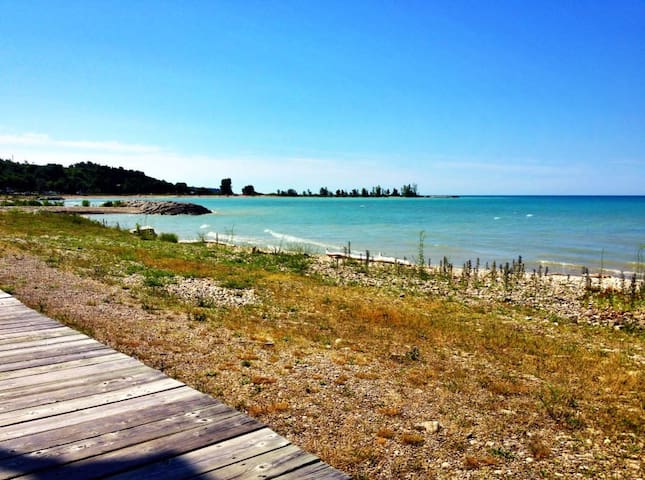
Boardwalk
Goderich Waterfront Boardwalk
Extends 1.5 km from the main beach at the mouth of the harbour to the Rotary Cove.
This incredible waterfront boardwalk stretches along three beautiful beaches, it offers a glimpse at the history of the harbour through the Marine Heritage Walking Tour.
Enjoy sunsets, picnic areas, playgrounds, rest stops and the waterfowl as you take a leisurely stroll.
DISTANCE - 1.5 km
DIFFICULTY LEVEL - Level 1 Easy
TRAIL USE - Walking, Wheelchair Accessible, no bicycles or dogs permitted on boardwalk (dog friendly area on part of St. Christophers beach and free run area south of Rotary Cove)
TRAIL HAZARDS - None evident
TRAIL SURFACE - All Boardwalk
COST FOR USING TRAIL - None
DRIVING DIRECTIONS - Take West Street from The square in downtown Goderich to the Main Beach, St. Christopher's Beach and Rotary Cove.
47 (рекомендации местных жителей)
Goderich
Goderich Waterfront Boardwalk
Extends 1.5 km from the main beach at the mouth of the harbour to the Rotary Cove.
This incredible waterfront boardwalk stretches along three beautiful beaches, it offers a glimpse at the history of the harbour through the Marine Heritage Walking Tour.
Enjoy sunsets, picnic areas, playgrounds, rest stops and the waterfowl as you take a leisurely stroll.
DISTANCE - 1.5 km
DIFFICULTY LEVEL - Level 1 Easy
TRAIL USE - Walking, Wheelchair Accessible, no bicycles or dogs permitted on boardwalk (dog friendly area on part of St. Christophers beach and free run area south of Rotary Cove)
TRAIL HAZARDS - None evident
TRAIL SURFACE - All Boardwalk
COST FOR USING TRAIL - None
DRIVING DIRECTIONS - Take West Street from The square in downtown Goderich to the Main Beach, St. Christopher's Beach and Rotary Cove.
Nature Reserve
This reserve is a 40 hectare former farm property that is owned by Ontario Nature. The nature trail winds through an old pine plantation and the remnants of the farm's orchards.
A side trail takes you through a white cedar forest and along a stream valley where it stops at an old dam where a sawmill once stood. Parking is available at the access point for the trail.
DISTANCE - 1.3 km, white pine loop, 0.6 cedar side trail (one way)
DIFFICULTY LEVEL - Level 3 some hills and natural path
TRAIL USE - Walking, pets on leash
TRAIL HAZARDS - Trail and steps can be slippery. Old building foundations near trail
TRAIL SURFACE - Natural surface
COST OF USING TRAIL - None
DRIVING DIRECTIONS - Hwy #21 between Bayfield and Goderich, take Kitchigami Rd. East. The reserve is located just past Porter's Hill Line, on the south side at #35913.
George G. Newton Nature Reserve
Kitchigami RoadThis reserve is a 40 hectare former farm property that is owned by Ontario Nature. The nature trail winds through an old pine plantation and the remnants of the farm's orchards.
A side trail takes you through a white cedar forest and along a stream valley where it stops at an old dam where a sawmill once stood. Parking is available at the access point for the trail.
DISTANCE - 1.3 km, white pine loop, 0.6 cedar side trail (one way)
DIFFICULTY LEVEL - Level 3 some hills and natural path
TRAIL USE - Walking, pets on leash
TRAIL HAZARDS - Trail and steps can be slippery. Old building foundations near trail
TRAIL SURFACE - Natural surface
COST OF USING TRAIL - None
DRIVING DIRECTIONS - Hwy #21 between Bayfield and Goderich, take Kitchigami Rd. East. The reserve is located just past Porter's Hill Line, on the south side at #35913.