
Isuf’s guidebook
Sightseeing
Located in Southern Albania, near the town of Çorovoda, the Osum Canyon is perhaps Albania’s best-known canyon, popular with local and foreign visitors alike. The river Osum passes through the city of Berat, a World Heritage Site, and flows through the canyon. The canyon features many underground passages and unexplored caves that are perfect for rafting.
In the spring, once the snow has melted, the rising level of the river waters enables visitors to explore the whole length of the canyon from the river itself. The rapids in this canyon are Class II, so visitors do not need prior white-water experience to navigate them. At the end of the summer, when the water level is lower, it is impossible to navigate the full length of the canyon. However, you can still hike around the canyon and go for a swim in various pools and streams.
The borders of the canyon have an atypical ecosystem that ensure an evergreen flora throughout the year, with Mediterranean bushes like heath and briar flourishing along with other lush plants and a diverse fauna. Small caves dot the slopes of the canyon, their walls pockmarked by erosion. Experts think that in the past, the river flowed underground, but over time the rock above the river eroded away, giving the canyon its current shape.
The canyons are 26 km (16 miles) long and have an altitude of 450 m. They are thought to have been formed 2-3 million years ago by water erosion. The canyon includes six narrow sections ranging from 1.5 m wide in the riverbed, up to 35 m wide further up the sides of the canyon.
Locals have been particularly creative in naming the many rock formations that surround the canyon, including names such as the Cathedral, the Eye, and the Demon’s Door. There is a mystical power to the canyon that has also inspired many interesting legends around it.
The most beautiful and spectacular canyon of the valley of Osum is the Gradeci Canyon, which stands close to a cave. Gradeci is 4 km long, 40 m high, and only 1.5 m wide in several spots. Its slopes descend rapidly into the river.
The other canyons of Osum are located 3 km south from the town of Çorovoda. They total 15 km in length and are magnificent natural objects. It is in this area that visitors can go canoeing, rafting, and kayaking. The area also offers several small beaches, such as Varishta.
11 (рекомендации местных жителей)

Osum Canyon
Located in Southern Albania, near the town of Çorovoda, the Osum Canyon is perhaps Albania’s best-known canyon, popular with local and foreign visitors alike. The river Osum passes through the city of Berat, a World Heritage Site, and flows through the canyon. The canyon features many underground passages and unexplored caves that are perfect for rafting.
In the spring, once the snow has melted, the rising level of the river waters enables visitors to explore the whole length of the canyon from the river itself. The rapids in this canyon are Class II, so visitors do not need prior white-water experience to navigate them. At the end of the summer, when the water level is lower, it is impossible to navigate the full length of the canyon. However, you can still hike around the canyon and go for a swim in various pools and streams.
The borders of the canyon have an atypical ecosystem that ensure an evergreen flora throughout the year, with Mediterranean bushes like heath and briar flourishing along with other lush plants and a diverse fauna. Small caves dot the slopes of the canyon, their walls pockmarked by erosion. Experts think that in the past, the river flowed underground, but over time the rock above the river eroded away, giving the canyon its current shape.
The canyons are 26 km (16 miles) long and have an altitude of 450 m. They are thought to have been formed 2-3 million years ago by water erosion. The canyon includes six narrow sections ranging from 1.5 m wide in the riverbed, up to 35 m wide further up the sides of the canyon.
Locals have been particularly creative in naming the many rock formations that surround the canyon, including names such as the Cathedral, the Eye, and the Demon’s Door. There is a mystical power to the canyon that has also inspired many interesting legends around it.
The most beautiful and spectacular canyon of the valley of Osum is the Gradeci Canyon, which stands close to a cave. Gradeci is 4 km long, 40 m high, and only 1.5 m wide in several spots. Its slopes descend rapidly into the river.
The other canyons of Osum are located 3 km south from the town of Çorovoda. They total 15 km in length and are magnificent natural objects. It is in this area that visitors can go canoeing, rafting, and kayaking. The area also offers several small beaches, such as Varishta.
The Heavenly Waterfall of the Gods
The Bogova Waterfall, rising 20 meters above its pool of aquamarine waters, is an exquisite still-untouched spot to get in touch with nature.
If you are looking for the exotic side of Albania, the one of the endless natural spectacles, pristine waters and untouched landscapes, Bogova Waterfall is a must! Situated on the left bank of the Osumi valley, this pearl of the Albanian landscape hides behind dense lush forests. Surrounded by rich hues of green, this waterfall’s appeal rests precisely in its isolation from the rest of the world.
Bogova Waterfall, photo by Alessandro Giangiulio, flickr.com.
How to get there
Your journey towards Bogova Waterfall begins at the village of the same name, the closest one to this natural monument. The origin of the name Bogova is Slavic, which in Albanian literally translates to “of the gods.” Upon reaching the village center, you will follow the trail in front of the bus station for about 30 minutes on foot and then walk alongside the river until you reach the waterfall. You will easily reach your destination by following the river and the road signs.
The waterfall
At a height of 20 meters, the waterfall stands above a pool of crystal clear waters that is 12 meters in depth. The scenery immerses you in a tropical paradise that seems to be entirely untouched. The sheer clarity of the water, the calming sounds of the waterfall and the green landscape that surround this area give you an idea of how the world must have been in its very beginnings. In the hot summer months, the temptation to dive into the refreshing water is great but only the truly courageous make it into its very cold temperatures.
Photo source: Greta Cufe, visitskrapar.com.
Transportation
Time flies here but, if you have used the public transportation from Berat, you will have to be careful to not forget your bearings and make sure to catch the last bus from the waterfall back to the city, leaving at 3PM. The surrounding villages also offer magnificent panoramas of vineyards and farms. Following your visit at the waterfall, you can grab some lunch in one of these villages on your return. The food is always delicious and fresh around these parts.
Directions: Follow the road Berat – Skrapar, stop in Bogova.

Bogovë Nature Park
The Heavenly Waterfall of the Gods
The Bogova Waterfall, rising 20 meters above its pool of aquamarine waters, is an exquisite still-untouched spot to get in touch with nature.
If you are looking for the exotic side of Albania, the one of the endless natural spectacles, pristine waters and untouched landscapes, Bogova Waterfall is a must! Situated on the left bank of the Osumi valley, this pearl of the Albanian landscape hides behind dense lush forests. Surrounded by rich hues of green, this waterfall’s appeal rests precisely in its isolation from the rest of the world.
Bogova Waterfall, photo by Alessandro Giangiulio, flickr.com.
How to get there
Your journey towards Bogova Waterfall begins at the village of the same name, the closest one to this natural monument. The origin of the name Bogova is Slavic, which in Albanian literally translates to “of the gods.” Upon reaching the village center, you will follow the trail in front of the bus station for about 30 minutes on foot and then walk alongside the river until you reach the waterfall. You will easily reach your destination by following the river and the road signs.
The waterfall
At a height of 20 meters, the waterfall stands above a pool of crystal clear waters that is 12 meters in depth. The scenery immerses you in a tropical paradise that seems to be entirely untouched. The sheer clarity of the water, the calming sounds of the waterfall and the green landscape that surround this area give you an idea of how the world must have been in its very beginnings. In the hot summer months, the temptation to dive into the refreshing water is great but only the truly courageous make it into its very cold temperatures.
Photo source: Greta Cufe, visitskrapar.com.
Transportation
Time flies here but, if you have used the public transportation from Berat, you will have to be careful to not forget your bearings and make sure to catch the last bus from the waterfall back to the city, leaving at 3PM. The surrounding villages also offer magnificent panoramas of vineyards and farms. Following your visit at the waterfall, you can grab some lunch in one of these villages on your return. The food is always delicious and fresh around these parts.
Directions: Follow the road Berat – Skrapar, stop in Bogova.
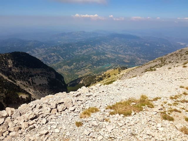
Mount Tomorr is a southern Albanian mountain 2,417 metres above sea level and is located in the Tomorr National Park. The park is known for its diverse species of deciduous and coniferous trees and a wide variety of flora. Many endangered species, such as bears, wolf, and birds of prey live in the park. umerous species of large mammals such as wolves, foxes, wild boars, roe deers, wild goats, rabbits, golden eagles, owles, and sparrowhawks can be found inside the national park.
At the summit there’s a mausoleum dedicated to Abbas Ali, a half-brother of Husayn, the grandson of the Prophet Mohmed.
The mountain is said to be the ancient home of the Illyrian gods. The Mountain is anthropomorphized in Albanian lore by Baba Tomor or Father Tomor, an old giant with a long flowing white beard and four female eagles hovering above him and perching on his snow-covered slopes.
There is another legend regarding the mountain. There were two handsome and brave brothers named Tomorr and Shpirag. The two brothers both fell in love with a beautiful maiden called Osumi. Osumi loved both of them and could not choose between them. Eventually the brothers became aware of the others’ attention. As neither would give Osumi up they brothers fought. Tomorr drew his sword and attacked, the sword’s wounds caused great crevasses on his brother. Shpirag wielded his flail which caused deep but small wounds on his brother. Thus, Tomorr’s body was left full of holes and Shpirag’s body was cut to pieces. As both brother lay dying Osumi began crying endlessly and her tears formed the Osumi River, which always lies between the Tomorr and Shpirag mountains.
Mount Tomorr offers a variety of activities including climbing, horseback riding, canoeing, and skiing

Национальный парк Томорр-Маунтин
Mount Tomorr is a southern Albanian mountain 2,417 metres above sea level and is located in the Tomorr National Park. The park is known for its diverse species of deciduous and coniferous trees and a wide variety of flora. Many endangered species, such as bears, wolf, and birds of prey live in the park. umerous species of large mammals such as wolves, foxes, wild boars, roe deers, wild goats, rabbits, golden eagles, owles, and sparrowhawks can be found inside the national park.
At the summit there’s a mausoleum dedicated to Abbas Ali, a half-brother of Husayn, the grandson of the Prophet Mohmed.
The mountain is said to be the ancient home of the Illyrian gods. The Mountain is anthropomorphized in Albanian lore by Baba Tomor or Father Tomor, an old giant with a long flowing white beard and four female eagles hovering above him and perching on his snow-covered slopes.
There is another legend regarding the mountain. There were two handsome and brave brothers named Tomorr and Shpirag. The two brothers both fell in love with a beautiful maiden called Osumi. Osumi loved both of them and could not choose between them. Eventually the brothers became aware of the others’ attention. As neither would give Osumi up they brothers fought. Tomorr drew his sword and attacked, the sword’s wounds caused great crevasses on his brother. Shpirag wielded his flail which caused deep but small wounds on his brother. Thus, Tomorr’s body was left full of holes and Shpirag’s body was cut to pieces. As both brother lay dying Osumi began crying endlessly and her tears formed the Osumi River, which always lies between the Tomorr and Shpirag mountains.
Mount Tomorr offers a variety of activities including climbing, horseback riding, canoeing, and skiing
A Spectacular Revelation
Waters flowing from Mount Tomorr into rugged limestone cliffs create the Sotira Waterfall, one of nature’s spectacles that attracts an increasing number of tourists year after year. Its waters fall from various heights of 20-100 meters, hitting the cliffs below at different speeds and creating an unforgettable, hypnotic scene!
Your journey toward Sotira Waterfall begins in the town Berat (district of Elbasan) which, situated only. The winding road is unpaved so it may take about 1.5 h with 4×4 vehicle to get to the starting point . Once you arrive in the small village, you will have to hike for about an hour and a half. In winter, it is a bit more challenging and sometimes impossible to pass it.
On the way to the waterfall you will not miss the fantastic lakes of Dardhe – All scenery is magnificent
2 Lakes of Dardhe
Man-made but looking so natural. Surrounded by greenery and crystal clear blue water, it makes you think you are in a fairy tale.
Both lakes are supplied with water by streams created by melting snow. Their location is very fantastic and offers a magnificent view of Mount Tomorri.
On the way back it is good to relax here and swim
the area is not touristic
Views of the hike through old villages ,valleys ,Tomorr mountain
The surrounding nature is untouched, bathed in astounding greenery and freshness created by the several springs scattered throughout the trail. At the end, the waterfall appears in all its glory! Thanks to a beautiful meadow nearby, you will be able to enjoy the spectacular views and the surrounding scenery. This one is definitely for the virgin nature lovers!
The Sotira River, created by the waterfall, flows throughout the surrounding forest, giving the already awe-inspiring panorama the perfect frame. With the right pair of shoes, you may even be able to get closer to the waterfall. A path has been created throughout the years to maximize the whole experience. Walk with care as the terrain can be a tad slippery!
To conclude, you may jot down some of your personal reflections inspired by this place. “Beauty will save the world” once wrote the great Russian writer Fyodor Dostoyevsky. Though you may have heard this phrase before, it takes some particularly beautiful places to bring it to life and imbue it with its full meaning. Here you will find traces of nature in its original, untouched glory. And, while the Sotira Waterfall will not save the world, the lucky ones who get to witness its beauty may feel encouraged to do so. This is one for the books!
Sotira waterfall
Local offering mule transport
A stop
through the nature
A nice meeting with goats
Hike views
hike views
Kotollak Lake
Mesme Lake
Cooling
Itinerary to Sotira Waterfall – off road vehicle required
The trip is fairly simple, following the road from Berat to Dardhe village . As you are in Dardhe village at the place called Cesma e Tarikos ( a small fountain ) follow the road going in the left -direction of the Lakes of Dardhe . On the right side of the lakes there is a road – Follow the road always the left one for about 1.5 km
After that you will see a village – and a small canyon – proceed on the left side of the canyon
About 1 km hike another small village – From there you can see the waterfall
There you can grab something to eat or drink at the small village diner/shop, and begin your hike. We would suggest bringing some food along for the hike. By doing so you can enjoy an idyllic picnic with a spectacular view in the meadow by the waterfall. Length of Hike: about 6 kilometers.
Our advice
As you approach the actual waterfall, the terrain becomes increasingly challenging. The descent into the gorge to the foot of the waterfall is about 30 meters on a slippery and exposed path so make sure you wear appropriate shoes to get really close!
Additional info
Locals are offering transport with 4×4 vehicle from Berat to Dardhe village
From the village to the waterfall locals are offering mule transport
Accommodation in local houses offered in Cafe Dardhe Village

Sotira's Waterfall
A Spectacular Revelation
Waters flowing from Mount Tomorr into rugged limestone cliffs create the Sotira Waterfall, one of nature’s spectacles that attracts an increasing number of tourists year after year. Its waters fall from various heights of 20-100 meters, hitting the cliffs below at different speeds and creating an unforgettable, hypnotic scene!
Your journey toward Sotira Waterfall begins in the town Berat (district of Elbasan) which, situated only. The winding road is unpaved so it may take about 1.5 h with 4×4 vehicle to get to the starting point . Once you arrive in the small village, you will have to hike for about an hour and a half. In winter, it is a bit more challenging and sometimes impossible to pass it.
On the way to the waterfall you will not miss the fantastic lakes of Dardhe – All scenery is magnificent
2 Lakes of Dardhe
Man-made but looking so natural. Surrounded by greenery and crystal clear blue water, it makes you think you are in a fairy tale.
Both lakes are supplied with water by streams created by melting snow. Their location is very fantastic and offers a magnificent view of Mount Tomorri.
On the way back it is good to relax here and swim
the area is not touristic
Views of the hike through old villages ,valleys ,Tomorr mountain
The surrounding nature is untouched, bathed in astounding greenery and freshness created by the several springs scattered throughout the trail. At the end, the waterfall appears in all its glory! Thanks to a beautiful meadow nearby, you will be able to enjoy the spectacular views and the surrounding scenery. This one is definitely for the virgin nature lovers!
The Sotira River, created by the waterfall, flows throughout the surrounding forest, giving the already awe-inspiring panorama the perfect frame. With the right pair of shoes, you may even be able to get closer to the waterfall. A path has been created throughout the years to maximize the whole experience. Walk with care as the terrain can be a tad slippery!
To conclude, you may jot down some of your personal reflections inspired by this place. “Beauty will save the world” once wrote the great Russian writer Fyodor Dostoyevsky. Though you may have heard this phrase before, it takes some particularly beautiful places to bring it to life and imbue it with its full meaning. Here you will find traces of nature in its original, untouched glory. And, while the Sotira Waterfall will not save the world, the lucky ones who get to witness its beauty may feel encouraged to do so. This is one for the books!
Sotira waterfall
Local offering mule transport
A stop
through the nature
A nice meeting with goats
Hike views
hike views
Kotollak Lake
Mesme Lake
Cooling
Itinerary to Sotira Waterfall – off road vehicle required
The trip is fairly simple, following the road from Berat to Dardhe village . As you are in Dardhe village at the place called Cesma e Tarikos ( a small fountain ) follow the road going in the left -direction of the Lakes of Dardhe . On the right side of the lakes there is a road – Follow the road always the left one for about 1.5 km
After that you will see a village – and a small canyon – proceed on the left side of the canyon
About 1 km hike another small village – From there you can see the waterfall
There you can grab something to eat or drink at the small village diner/shop, and begin your hike. We would suggest bringing some food along for the hike. By doing so you can enjoy an idyllic picnic with a spectacular view in the meadow by the waterfall. Length of Hike: about 6 kilometers.
Our advice
As you approach the actual waterfall, the terrain becomes increasingly challenging. The descent into the gorge to the foot of the waterfall is about 30 meters on a slippery and exposed path so make sure you wear appropriate shoes to get really close!
Additional info
Locals are offering transport with 4×4 vehicle from Berat to Dardhe village
From the village to the waterfall locals are offering mule transport
Accommodation in local houses offered in Cafe Dardhe Village
Local tour operator in Berat offering a wide choice of tours and excursions in Berat as well transfer services all over Albania and Balkans
Visit Albania Tour Operator (VATO)
Local tour operator in Berat offering a wide choice of tours and excursions in Berat as well transfer services all over Albania and Balkans
Roshnik village is about 12 km from Berat. The village its very interesting and it offers nice views of the nature surroundings. It has a small lake and hills planted with olives and grapes.
Several restaurants are in the area and also a small family winery
Roshnik’s Lake
Roshnik village is about 12 km from Berat. The village its very interesting and it offers nice views of the nature surroundings. It has a small lake and hills planted with olives and grapes.
Several restaurants are in the area and also a small family winery
Sinje village is located about 16 km from Berat. Famous for its position close to Shpirag Mountain. The village offers nice views of the sunset and also it has several hiking trials. One of these trials will take you to the summit of Shpirag mountain. A restaurant located in the village where they serve different types of food.
Синье
Sinje village is located about 16 km from Berat. Famous for its position close to Shpirag Mountain. The village offers nice views of the sunset and also it has several hiking trials. One of these trials will take you to the summit of Shpirag mountain. A restaurant located in the village where they serve different types of food.
REMNANTS OF THE CITY’S MESMERISING HISTORIC CENTRE
One of Berat’s main Ottoman-era attractions, this large complex includes a beautiful mosque, an ornate tekke, and stunning wood-carved balconies – a reminder of this area’s important central location in the past.
Berat is one of the most historically and culturally significant cities in southeastern Albania. The Medieval Centre of Berat is a great representation of Berat’s influential character. Built during the Ottoman rule of Albania, the locals called this significant place “Sheria e Beratit”, which, at the time, meant the “centre of Berat”. Unfortunately, as a result of the Second World War, the library and school of the old centre were destroyed, however, several beautiful monuments have survived and can be visited today. The present-day complex consists of the King Mosque, the Halveti Tekke, intricate wooden balconies, and several monumental tombs.
The King Mosque
Built by Sultan Bajaziti II around 1480, the King Mosque, located within the complex, is one of the oldest in Berat. The mosque consists of a minaret, a hall and a portico while many windows abundantly illuminate the entire interior of this facility. Inside, the building is divided into two floors, whose architecture includes a soothing combination of columns, arches, and colourful decorations. Another extraordinary element of its architecture is the wood carving, which beautifully enriches the interior atmosphere.
The King Mosque, photo by IntoAlbania.
Мечеть Короля
REMNANTS OF THE CITY’S MESMERISING HISTORIC CENTRE
One of Berat’s main Ottoman-era attractions, this large complex includes a beautiful mosque, an ornate tekke, and stunning wood-carved balconies – a reminder of this area’s important central location in the past.
Berat is one of the most historically and culturally significant cities in southeastern Albania. The Medieval Centre of Berat is a great representation of Berat’s influential character. Built during the Ottoman rule of Albania, the locals called this significant place “Sheria e Beratit”, which, at the time, meant the “centre of Berat”. Unfortunately, as a result of the Second World War, the library and school of the old centre were destroyed, however, several beautiful monuments have survived and can be visited today. The present-day complex consists of the King Mosque, the Halveti Tekke, intricate wooden balconies, and several monumental tombs.
The King Mosque
Built by Sultan Bajaziti II around 1480, the King Mosque, located within the complex, is one of the oldest in Berat. The mosque consists of a minaret, a hall and a portico while many windows abundantly illuminate the entire interior of this facility. Inside, the building is divided into two floors, whose architecture includes a soothing combination of columns, arches, and colourful decorations. Another extraordinary element of its architecture is the wood carving, which beautifully enriches the interior atmosphere.
The King Mosque, photo by IntoAlbania.
The Halveti Tekke
The Halveti Tekke within Medieval Centre of Berat, is yet another impressive monument in this complex, and one of the most interesting architectural structures of the city. The tekke was built in the 15th century and restored by Ahmet Kurt Pasha towards the end of the 17th century. The structure, belonging to the sect of the same name, is located to the east of the King Mosque, in the renowned Mangalem neighborhood. The tekke is surrounded by a courtyard that includes several konakë, the local term for “balconies.”
Helveti Tekke entrance, photo by IntoAlbania.
Once inside this rare structure, characterised by beautiful woodwork and stunning colors, one sees an anteroom that leads to the prayer room. The walls display beautiful frescoes and the ceiling, the building’s most beautiful part, is elegantly decorated with hues of green, gold, violet, red, and blue.
The ceiling of the Helveti Tekke, photo by IntoAlbania.
Monumental Tombs, Balconies, and More
The tombs of Ahmet Kurt Pasha and his son are located right next to the prayer hall. The balconies are all constructed in wood and are held by several columns. These small rooms hosted believers, who came to conduct their religious rites, or students who continued studying in the once-existing schools. For a nice conclusion to your visit in this religious and cultural centre, you should also take the opportunity to visit the Sheh Qerim Tekke, located nearby.
The Monumental Tombs at the Medieval Center in Berat, photo by IntoAlbania.
OPENING HOURS
ADDRESS
Kurt Pasha Street (Rruga), Berat
Halveti Tekke, Berat
The Halveti Tekke
The Halveti Tekke within Medieval Centre of Berat, is yet another impressive monument in this complex, and one of the most interesting architectural structures of the city. The tekke was built in the 15th century and restored by Ahmet Kurt Pasha towards the end of the 17th century. The structure, belonging to the sect of the same name, is located to the east of the King Mosque, in the renowned Mangalem neighborhood. The tekke is surrounded by a courtyard that includes several konakë, the local term for “balconies.”
Helveti Tekke entrance, photo by IntoAlbania.
Once inside this rare structure, characterised by beautiful woodwork and stunning colors, one sees an anteroom that leads to the prayer room. The walls display beautiful frescoes and the ceiling, the building’s most beautiful part, is elegantly decorated with hues of green, gold, violet, red, and blue.
The ceiling of the Helveti Tekke, photo by IntoAlbania.
Monumental Tombs, Balconies, and More
The tombs of Ahmet Kurt Pasha and his son are located right next to the prayer hall. The balconies are all constructed in wood and are held by several columns. These small rooms hosted believers, who came to conduct their religious rites, or students who continued studying in the once-existing schools. For a nice conclusion to your visit in this religious and cultural centre, you should also take the opportunity to visit the Sheh Qerim Tekke, located nearby.
The Monumental Tombs at the Medieval Center in Berat, photo by IntoAlbania.
OPENING HOURS
ADDRESS
Kurt Pasha Street (Rruga), Berat
ONUFRI ICONOGRAPHIC MUSEUM
The Museum holds 200 artwork objects, icons and liturgical items dated from the 14th century to the 20th, brought together from several churches and monasteries of the region. You will see icons painted by renown Albanian icon painters such as Onufri, Onufri’s son Nikolla, Onufër the Cypriot, David Selenica, Kostandin Shpataraku, the Çetiri tribe with Gjergji, Johani, Nikolla, Naumi, and his son Gjergji, as well as anonymous painters. By their side, the liturgical items bear the signature of Albanian silversmiths of various times, and the Cathedral woodcarvings were crafted by masters Stefan Barka and Naum Ngjela, from Misrasi and Lavdari, in Opari, in the early 19th Century.
The iconostasis of the cathedral of the Dormition of St Mary was created in 1807. It is considered a finest piece of the Albanian woodcarving. The iconostasis decorations feature some Baroque-style features and principles, a dominant and distinctive trend of churches built in the Balkans during the 18th and 19th centuries. All these motifs are intertwined with other elements of Byzantine tradition.
In a wooden arch near Iconostasis are preserved the remains or relics of two Saints Gorazdi and Angjellari (disciples of Saints Metodi and Kirili) who are thought to have accomplished their mission in the 9th century AD.
The Purple Codex of Berat and the Golden Codex of Anthimos were discovered beneath the apse floor on August 12th, 1968 inside a small metal box hidden in the crypt.They are also known as the “Codex Purpureus Beratinus” from the 6th century A.D, and the “Codex Aureus Anthimi” from the 9th century A.D, or as the Codices of Berat. They are monuments of culture and civilization, and genuine encyclopedias of the Christian thinking.The two Berat Codices are listed in the list of humanity’s most important works, known as “Memoire du Monde” under the protection of UNESCO.
Muzeu Kombëtar Ikonografik "Onufri"
ONUFRI ICONOGRAPHIC MUSEUM
The Museum holds 200 artwork objects, icons and liturgical items dated from the 14th century to the 20th, brought together from several churches and monasteries of the region. You will see icons painted by renown Albanian icon painters such as Onufri, Onufri’s son Nikolla, Onufër the Cypriot, David Selenica, Kostandin Shpataraku, the Çetiri tribe with Gjergji, Johani, Nikolla, Naumi, and his son Gjergji, as well as anonymous painters. By their side, the liturgical items bear the signature of Albanian silversmiths of various times, and the Cathedral woodcarvings were crafted by masters Stefan Barka and Naum Ngjela, from Misrasi and Lavdari, in Opari, in the early 19th Century.
The iconostasis of the cathedral of the Dormition of St Mary was created in 1807. It is considered a finest piece of the Albanian woodcarving. The iconostasis decorations feature some Baroque-style features and principles, a dominant and distinctive trend of churches built in the Balkans during the 18th and 19th centuries. All these motifs are intertwined with other elements of Byzantine tradition.
In a wooden arch near Iconostasis are preserved the remains or relics of two Saints Gorazdi and Angjellari (disciples of Saints Metodi and Kirili) who are thought to have accomplished their mission in the 9th century AD.
The Purple Codex of Berat and the Golden Codex of Anthimos were discovered beneath the apse floor on August 12th, 1968 inside a small metal box hidden in the crypt.They are also known as the “Codex Purpureus Beratinus” from the 6th century A.D, and the “Codex Aureus Anthimi” from the 9th century A.D, or as the Codices of Berat. They are monuments of culture and civilization, and genuine encyclopedias of the Christian thinking.The two Berat Codices are listed in the list of humanity’s most important works, known as “Memoire du Monde” under the protection of UNESCO.
The St. Michael's Church (Albanian: Kisha e Shën Mëhillit) is a medieval Byzantine church outside the Kalaja district on a hilltop of the city of Berat of Southern Albania. As part of the Historic Centres of Berat and Gjirokastër UNESCO World Heritage Site, the church was possibly constructed in the fourteenth century and is dedicated to the Christian archangel of Michael.
The church is relative small in size and was constructed on the south of the Kalaja district on a steep rock. It is a cruciform chapel instilled without any internal support, with a dome on drum and narthex on the west section.[5] It was built on a cruciform plan with a dome on the top. The walls are characterized by combination of rows of red brick with stone.
Inside the temple, the remains of painting walls retains only few trace. A collection of frescoes and icons have been preserved nowaday
The path to the church offers nice views of Gorica old town and of the city center
PW3W+WMC
The St. Michael's Church (Albanian: Kisha e Shën Mëhillit) is a medieval Byzantine church outside the Kalaja district on a hilltop of the city of Berat of Southern Albania. As part of the Historic Centres of Berat and Gjirokastër UNESCO World Heritage Site, the church was possibly constructed in the fourteenth century and is dedicated to the Christian archangel of Michael.
The church is relative small in size and was constructed on the south of the Kalaja district on a steep rock. It is a cruciform chapel instilled without any internal support, with a dome on drum and narthex on the west section.[5] It was built on a cruciform plan with a dome on the top. The walls are characterized by combination of rows of red brick with stone.
Inside the temple, the remains of painting walls retains only few trace. A collection of frescoes and icons have been preserved nowaday
The path to the church offers nice views of Gorica old town and of the city center
The main boulevard of Berat. In the evening is very popular and you will see the locals hung out . Several bars and cafes are located at this place. During the summer days its better to hung out there after 18 :00

Bulevardi Republika, Berat, Албания
The main boulevard of Berat. In the evening is very popular and you will see the locals hung out . Several bars and cafes are located at this place. During the summer days its better to hung out there after 18 :00
Dardhe village - A rural village 24 km from Berat. The village is famous for the views of Tomorr Mountain and this is the place where you can start the hike to the summit of Tomorr mountain. 4x4 vehicle is required to do this journey
Dardhë Berat
Dardhe village - A rural village 24 km from Berat. The village is famous for the views of Tomorr Mountain and this is the place where you can start the hike to the summit of Tomorr mountain. 4x4 vehicle is required to do this journey
The highest summit of Tomorr Mountain. If you like adventures this is a must. The hike to the summit is challenging and it offers great views of nature surroundings. Starting point is the village of Qafe Dardhe 24 km from Berat. To reach the starting point 4x4 vehicle needed.
Кека Партизан, Албания
The highest summit of Tomorr Mountain. If you like adventures this is a must. The hike to the summit is challenging and it offers great views of nature surroundings. Starting point is the village of Qafe Dardhe 24 km from Berat. To reach the starting point 4x4 vehicle needed.
Neighborhoods
Down in the traditionally quarter, there are three grand mosques: the Sultan's Mosque, the Lead Mosque and the Bachelors' Mosque. All are worth a visit and each has its own idiosyncratic design and history.
The 16th-century Sultan's Mosque is one of the oldest in Albania. The Helveti teqe (a place of worship for those practising the Bektashi branch of Islam) behind the mosque has a beautiful carved ceiling and was specially designed with acoustic holes to improve the quality of sound during meetings. The Helveti, like the Bektashi, are a dervish order, or brotherhood, of Muslim mystics.
The big mosque on the town square is the 16th-century Lead Mosque, so named because of the lead coating its sphere-shaped dome. The 19th-century Bachelors' Mosque is down by the Osumi River. This mosque was built for unmarried shop assistants and junior craftsmen, and is perched between some fine Ottoman-era shopfronts along the river. At the time of research it was closed for renovations.
Suggest an Edit

Mangalem
Down in the traditionally quarter, there are three grand mosques: the Sultan's Mosque, the Lead Mosque and the Bachelors' Mosque. All are worth a visit and each has its own idiosyncratic design and history.
The 16th-century Sultan's Mosque is one of the oldest in Albania. The Helveti teqe (a place of worship for those practising the Bektashi branch of Islam) behind the mosque has a beautiful carved ceiling and was specially designed with acoustic holes to improve the quality of sound during meetings. The Helveti, like the Bektashi, are a dervish order, or brotherhood, of Muslim mystics.
The big mosque on the town square is the 16th-century Lead Mosque, so named because of the lead coating its sphere-shaped dome. The 19th-century Bachelors' Mosque is down by the Osumi River. This mosque was built for unmarried shop assistants and junior craftsmen, and is perched between some fine Ottoman-era shopfronts along the river. At the time of research it was closed for renovations.
Suggest an Edit
Gorica neighborhood is part of UNESCO. The place is famous for the old bridge wich is build in 1777 and recently for the pedestrian street. It has nice narrow streets , 2 churches and it offers nice views of Mangalem quarter

Gorica
Gorica neighborhood is part of UNESCO. The place is famous for the old bridge wich is build in 1777 and recently for the pedestrian street. It has nice narrow streets , 2 churches and it offers nice views of Mangalem quarter
hidden behind the crumbling walls of the fortress that crowns the hill above Berat is the whitewashed, village-like neighbourhood of Kala; if you walk around the quiet cobbled streets of this ancient neighbourhood for long enough you'll invariably stumble into someone's courtyard, thinking it's a church or ruin (no one seems to mind, though).
In spring and summer the fragrance of chamomile is in the air (and underfoot), and wildflowers burst from every gap between the stones, giving the entire place a magical feel.
The highest point is occupied by the Inner Fortress, where ruined stairs lead to a Tolkienesque water reservoir. Views are spectacular in all directions. It's a steep 10 to 15-minute walk up the hill from the centre of town. For an even more impressive view, continue on right to the far southern end of the complex (the total opposite end from the main entrance) and you'll get to a viewpoint from where you can peer down onto the town far below. In summer, men sell fresh fruit from a stall here.
The Kala quarter's biggest church, Church of the Dormition of St Mary (Kisha Fjetja e Shën Mërisë), is the site of the Onufri Museum. Ask at the Onufri Museum if you can see the other churches and tiny chapels in Kala (which are otherwise normally kept locked), including St Theodore, close to the citadel gates; the substantial and picturesque Church of the Holy Trinity, below the upper fortress; and the little chapels of St Mary Blachernae and St Nicholas. Some of the churches date back to the 13th century. Also keep an eye out for the Red Mosque, by the southern Kala walls, which was the first in Berat and dates back to the 15th century.
12 (рекомендации местных жителей)
Бератский замок
5001 Rruga Mihal Komnenahidden behind the crumbling walls of the fortress that crowns the hill above Berat is the whitewashed, village-like neighbourhood of Kala; if you walk around the quiet cobbled streets of this ancient neighbourhood for long enough you'll invariably stumble into someone's courtyard, thinking it's a church or ruin (no one seems to mind, though).
In spring and summer the fragrance of chamomile is in the air (and underfoot), and wildflowers burst from every gap between the stones, giving the entire place a magical feel.
The highest point is occupied by the Inner Fortress, where ruined stairs lead to a Tolkienesque water reservoir. Views are spectacular in all directions. It's a steep 10 to 15-minute walk up the hill from the centre of town. For an even more impressive view, continue on right to the far southern end of the complex (the total opposite end from the main entrance) and you'll get to a viewpoint from where you can peer down onto the town far below. In summer, men sell fresh fruit from a stall here.
The Kala quarter's biggest church, Church of the Dormition of St Mary (Kisha Fjetja e Shën Mërisë), is the site of the Onufri Museum. Ask at the Onufri Museum if you can see the other churches and tiny chapels in Kala (which are otherwise normally kept locked), including St Theodore, close to the citadel gates; the substantial and picturesque Church of the Holy Trinity, below the upper fortress; and the little chapels of St Mary Blachernae and St Nicholas. Some of the churches date back to the 13th century. Also keep an eye out for the Red Mosque, by the southern Kala walls, which was the first in Berat and dates back to the 15th century.
Food scene
A small restaurant located inside Berat castle offering traditional food. The restaurant offers nice views at the corner from Tomorr Mountain and the city of Berat.
Mbrica Restaurant Traditional Food
A small restaurant located inside Berat castle offering traditional food. The restaurant offers nice views at the corner from Tomorr Mountain and the city of Berat.
Small restaurant Located in Mangalem quarter close to the Mosque. The restaurant has a veranda and an interior place and it serves traditional food as well some types of pasta
Friendly House
Small restaurant Located in Mangalem quarter close to the Mosque. The restaurant has a veranda and an interior place and it serves traditional food as well some types of pasta
Medina Pizza Halal
Piza Hallall in Berat - the place is mostly to take away and for delivery.
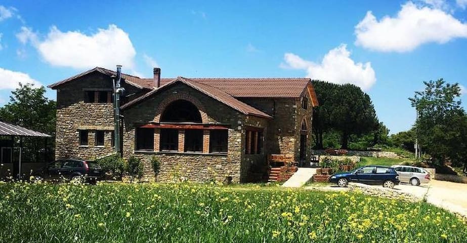
A winery and restaurant located about 16 km from the city of Berat. There you can make a wine tasting or also have lunch or dinner. The winery is located in a scenic position and it offers nice views of nature surroundings
Pupa Winery & GuestHouse
A winery and restaurant located about 16 km from the city of Berat. There you can make a wine tasting or also have lunch or dinner. The winery is located in a scenic position and it offers nice views of nature surroundings
This is the biggest winery in Albania. Build in 1960 during the communist era by Russian architects. Now a day its a private company and it makes the production of different types of wines and spirits. The winery has a wine tasting room and it host wine tasting tours
Kantina Luani
This is the biggest winery in Albania. Build in 1960 during the communist era by Russian architects. Now a day its a private company and it makes the production of different types of wines and spirits. The winery has a wine tasting room and it host wine tasting tours
Cobo winery - Located 12 km from Berat. Famous for the production of different types of local wines like Pules and Shesh I Zi. It is opened every day and it offers wine tasting tours or simple visit just to buy wine
Çobo Winery
Cobo winery - Located 12 km from Berat. Famous for the production of different types of local wines like Pules and Shesh I Zi. It is opened every day and it offers wine tasting tours or simple visit just to buy wine